

report by Edmund Dummer and Thomas Wiltshaw

scroll cartouche
title
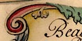
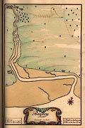
Bottom centre of the map is a scroll cartouche with some acanthus leaf decoration, tinted in reds and greens. The map title is:-
Beauley. RiverThe title cartouche contains:-
scale
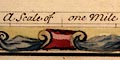
A Scale of one Milewith divisions at quarter miles. The 1 mile = 72.1mm; assuming a modern statute mile this gives a scale 1 to 22290; or, if a sea mile of 6082.95 feet, 1 to 25715. The map scale is about:-
1 to 22000 to 1 to 25000
2.5 or 3 inches to 1 mile
compass rose
up is NW

The map has a compass rose. There are four star points for the cardinal directions, tinted red/pink, and four more for the half cardinal directions, tinted grey/blue. North is marked by a yellow fleur de lys. Up on the sheet is NNW.
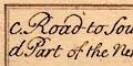
There are tables at left and right at the bottom of the map, in plain rectangular cartouches. These explain letters used to mark some features of the map. Eg:-
b. Road to Lymington
foreshore
The sea is plain. The expanse of sandy or muddy flats across the river mouth is tinted sandy brown.
bridges
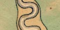
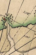
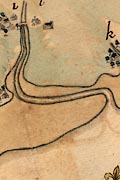
The subject of the map is the Beaulieu River, which is drawn from its large bends seaward for about 7 miles inland. Various creeks are shown in the estuary mudflats and there is a series of meanders about 5-6 miles from the sea.
At Beaulieu village a bridge is shown by a double line arching over the river. The river is tinted pale blue along its edge.
The land is tinted pale green with suggestions of low hills drawn in profile.
forests
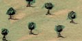
Trees are drawn sparingly over the land, but grouped closer in:-
d Part of the New Forestwhich is clearly bounded by a line.
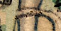
Trees are drawn in settlements, with a small wood SE of Beaulieu.
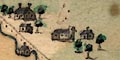
Settlements are drawn by small buildings, roofs tinted grey. One place is marked by letter:-
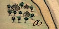
a. Ginnswhich is a great house rather than a village.
c. Road to SouthamptonThis route crosses to Southampton over the Hythe Ferry. Another road is marked:-
b. Road to Lymingtonon the west side of the village. But nothing of the road is drawn.
Collins 1693
Dummer 1698
Click images to enlarge
Dummer and Wiltshaw's chart of Beaulieu has details not shown in the chart by Greenvile Collins.
report by Edmund Dummer and Thomas Wiltshaw