
 Return to list of Features

NB: typical illustrated examples are described, NOT ALL examples.
absence of evidence is not evidence of absence
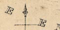
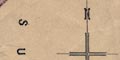
The map is labelled at the edges:-
Oriens
Meridio
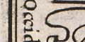
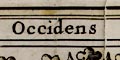
Occidens
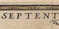
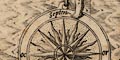
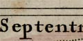
SeptenrioIt has Jerusalem at the centre and East at the top. The inner circular frame has wind heads and named winds.
The distorted British Isles sitting at the northwest corner of the map has North East at the top.
The map is drawn on a parchment to be held sideways; it is labelled so that East is at the top of the sheet.
The map is printed with North at the top of the page.
The map is printed with West at the top of the page; this puts the islands conveniently across a double page spread of a folded sheet in an atlas. The borders are labelled:-
[ ]
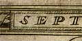
SEPTENTRIO
ORIENS
MERIDIES
Printed in 3 of the borders are directions:-
West [top]
Zuyd [left]
Oost [bottom]The map is printed with West at the top of the sheets.
The map is printed with north at the top. The four map borders are labelled:-
Septentrio.short for Septentriones,
Oriens.
Meridies.
Occidens.North, East, South, West.
The four borders of the map sheet are labelled with directions:-
SEPTENTRIO
ORIENS
MERIDIES
OCCIDENS
The map is printed with north at the top.
The map is printed with North at the top of the page. The four borders are labelled:-
SEPTENTRIO
ORIENS
MERIDIES
OCCIDENSAt the middle of each side, against the border, is a half compass rose; marked for the cardinal, half cardinal, false and by points; North marked with a fleur de lys, East with a cross.
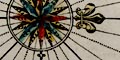
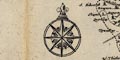
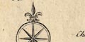
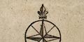
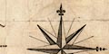
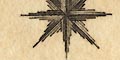
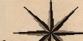
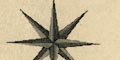
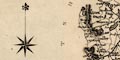
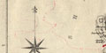
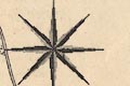
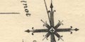
The map has a compass rose with star points for the cardinal, half cardinal and false points. Rhumb lines for these and the by points radiate from the rose. The main points are labelled:-
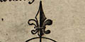
N NE E SE S SW W NWand north is marked with a fleur de lys.
The map is not quite 'upright', up on the sheet is about NWbyN.
The map is drawn with south at the top, ie as if looking out to sea from Hampshire. The right border is labelled:-
West
The map borders are labelled:-
OCCIDENS
SEPTEN.
ORIENS
MERIDIESIt is printed with West at the top of the page. Its forerunner, Munster 1540, had East at the top.
The map borders have labels:-
NORTHE
EAST
SOUTHE
WESTThere are also several compass roses. The grandest, printed on the left has label shape pointers for the cardinal, half cardinal, false and bye points, bearing the directions, as:-
NORTH
N B E
N N E
N E B N
NORTH E
N E B E
E N E
E B N
EASTetc. On each rose, North is marked by a fleur de lys. The compass rose in the North Sea is decorated with an armillary sphere in the middle, the rose in the English Channel has a rose.
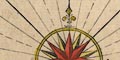
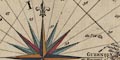
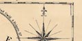
The four compass roses are drawn along the Armada track, and at each there is a wind head, a winged cherub head puffing out a wind. The compass rose on the left, in the Atlantic, the last stage of the Armada's journey homeward, has a scroll:-
A DEO FACTUM ESTroughly translated 'Made by God'. The wind that blew away the Armada.
The map has labelled borders:-
SEPTENTRIO / ORIENS / MERIDIES / OCCIDENS
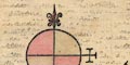
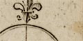
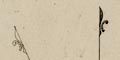
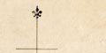
The compass rose has a fleur de lys to mark north, and inscription:-
Septenfor septentriones, refering to the seven stars.
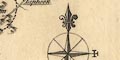
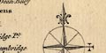
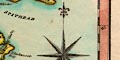
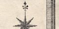
Printed in the sea area south of Hayling is a compass rose with broad star points for the cardinal, half cardinal, false and by points. The cardinal directions are labelled:-
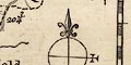
Septen / or / merid / ocfor septentriones - north, oriens - east, meridiens - south, occidens - west. The compass is suspended from a ring held by a cherub who has a pair of compasses in its other hand. The map is orientated with up being north.
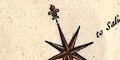
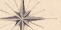
Printed in the middle is a compass rose with star points for the cardinal, half cardinal, false and by points. Rhumb lines radiate from the rose, engraved across sea areas, but no the land. North is indicated by a fleur de lys.
The map borders are labelled:-
Occidens
Septentrio
Oriens
MeridiesThe map is printed with West at the top of the page.
The left and right map borders are labelled:-
Occidens
Oriensfor west and east.
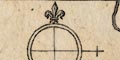
Compass rose and scale line are combined, together with an inscription of the map maker's and engraver's names.
Jo: Norden descripsit WHole sculp
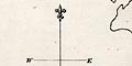
The cardinal, half cardinal, and false points of the compass are indicated, north is marked with a fleur de lys. The cardinal points are named:-
SEPTSeptentriones: refering to the seven stars that make up the constellation of The Bear, or Plough, that is a pointer for the Pole Star in the North
ORIOriens: from the Latin orior, to rise, where the sun rises in the East
MERIMeridiens: middle of the day, where the sun is then in the South
OCCIOccidens: from the Latin occido, to fall or set, where the sun sets in the West
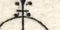
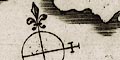
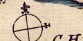
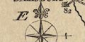
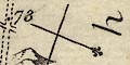
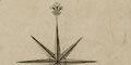
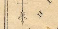
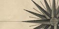
Printed lower left of centre is a compass rose. This is gaudily and clumsily painted. It has star points for the cardinal, half cardinal and false points, and lines for the by points. North is marked with a fleur de lys; east with a cross; south with a crescent; and west with three ?bezzants. All except the west are traditional signs for the purpose, though only the fleur de lys is in common use today. North is aligned up a meridian line, and, generally, the map is printed with north at the top of the page.
Additionaly, the map's four borders are labelled:-
NORTH
EAST
SOUTH
WEST
No indication is given, up is North is assumed.
The map is printed with north at the top. The map borders are labelled:-
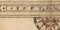
SEPT
ORIENS
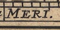
MERI.
OCCIDENSfor septentriones - north, east, meridies - south, and west.
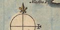
The map has no north indicator; it is printed with north at the top of the sheet.
Printed left of centre is a magnificent compass rose; star point for cardinal, half cardinal, and false points, and lesser points for the by points, North marked by a fleur de lys. Rhumb lines are drawn from the rose across the sea areas. The map is printed with North at the top of the sheet.
The space for a map is tiny; the map is really small. To fit it in better the map is turned nearly 180 degrees from the usual 'up is N', the thumbnail is 'up is SE', roughly: but, judging by the place names on the map it is intended to be read 'up is N'.
The chart has two compass roses; North marked by a fleur de lys; East by a circle and 3 circles. The chart is printed with North at the top of the sheet. Rhumb lines are drawn across the sea areas.
Printed in the centre is a compass rose; North marked by a fleur de lys; East by a circle and 3 circles. The chart is printed with SSE at the top.
Rhumb lines are drawn from the compass rose and from 16 other centres.
Printed lower middle is a compass rose; star points for cardinal and half cardinal directions, lines for false and by points, North marked by a fleur de lys, E S and W labelled. The map is printed with North at the top of the sheet.
The map has no compass rose. Top and bottom borders are labelled.
Septentrio
Oriens
Meridies
Occidens
The map has both compass rose and labelled borders.
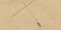
Printed lower left is a compass rose; star points for the cardinal, half cardinal, and false points, and lines for the by points. All directions are extended by rhumb lines across the sea area as far as the coast. North is marked by a fleur de lys, and east by a cross. The map is orientated with west at the top of the sheet, presumably a convenience have labels reading easily on a map on a double page spread in its atlas.
The four borders are labelled:-
Occidens
Septentrio
Oriens
Meridies
There is a compass rose; N marked by a fleur de lys, East by a circle with 3 circles. The chart is printed with North at the top of the sheet.
Rhumb lines are drawn from the compass rose and another 16 centres.
Printed on the left is a compass rose; star points for the cardinal and half cardinal directions, lines for the false points, North marked by a fleur de lys. The map is printed with North at the top of the sheet.
Printed on the left is a compass rose; circle, lines for the cardinal directions, labelled:-
N E S W
The three banners carried by cherubs are clearly engraved, readable.
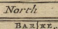
The 1st scroll is a strip road map titled:-
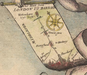
The Road from LONDON TO BARWICKLondon is at the bottom with a road northeast to Harwic[ ]. The road north goes through Shorditch, Kingsland with turnings to Islington and Hackney, Newington, to Tottenham with its high Crosse, just over 5 miles into Middlesex. The miles from London are marked.
A compass rose on the scroll has star points for cardinal and half cardinal directions; North marked by a fleur de lys. Up the scroll is roughly north.
The 2nd scroll has a street map of:-
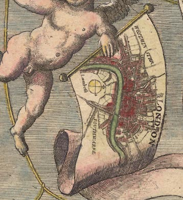
LONDONwith Westminster, Lambeth and Southwark labelled. This is orientated with North roughly at the top, the scroll held sideways. There is a simple compass rose, lines for the cardinal directions; fleur de lys for North, a cross for East.
The 3rd scroll has a road map of the area of:-
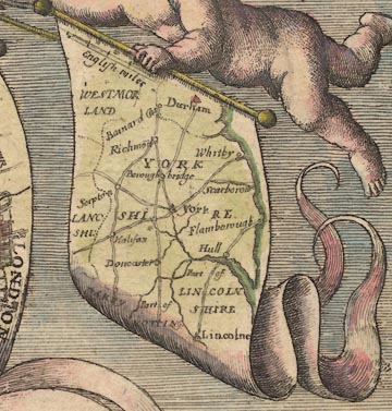
YORKSHIREand surrounding counties, parts of Westmorland, Lanc[ ]shi, Lincolnshire, etc. The map is a road map of the area, but not a strip map. This map is orientated with North at the top.
There is a scale line of:-
English milesThis is [surely] not meant as a serious scale to the map. Its 40 miles = 15.3mm gives a scale about 1 to 4200000, 66 miles to 1 inch. Measuring the positions of York, Lincoln and Durham does not reveal anything interesting, it wasn't likely to!
The four map borders are labelled:-
NORTH
EAST
SOUTH
WESTThe map is printed with North at the top of the sheet.
There is a compass rose, a plain circle, lines for the four cardinal directions, a fleur de lys for north, and a cross for east.
There are three compass roses on the map, in sea around the island. They have star points for cardinal, half cardinal, false and by points. There are rhumb lines across sea areas; solid for all except the by point directions which are dotted. The map is printed with North at top of the sheet.
The map's orientation is given by a compass rose. This has star points for the cardinal and half cardinal points; stubby star points for the false points; north is marked by a fleur de lys. Map north is up on the sheet.
There are several compass roses; North marked by a fleur de lys, East by a cross. The chart is printed with North at the top of the sheet.
There are rhumb lines drawn from the compass roses and other points, in a circle of 16 centres.
The map has several compass roses; star points for cardinal and half cardinal and false points, lines for bye points, North marked by a fleur de lys, East by three balls. The map is printed with North at the top of the sheet.
The map is printed with North at the top of the sheet.
As original.
Printed on the right is a compass rose; star points for cardinal directions, lines for half cardinal directions, North marked by a fleur de lys, East by a cross. The map is printed with North at the top of the sheet.
The map has several compass roses; North marked by a fleur de lys, East by a circle and 3 circles. These and various other centres are used for rhumb lines.
The chart also has labelled borders to show its orientation:-
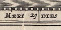
Septentrion
Orient
Midy
Occident
Near the bottom right of centre is half a compass rose with star points for the cardinal, half cardinal, and false points, and lines for the by points. From these there are rhumb lines across land and sea. Half way up the chart, left and right, are centres for two more sets of rhumb lines; bold for the cardinal and half cardinal directions, light for the false, and dotted for the by point
There are several compass roses on the chart, each with rhumb lines running over sea and land. The rose has star points for cardinal, half cardinal and false points. The rhumb lines are bold continuous lines for cardinal and half cardinal directions, continuous lines for false points, dotted lines for by points.
The map's orientation is given by labels in the four borders:-
North
East
South
WestThere is no compass rose.
The chart has several compass roses; North marked by a fleur de lys, East by a cross. The map is printed with North at the top of the page.
The compass roses and other points, one group arranged in a circle of 16, are centres for rhumb lines.
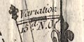
Printed on the left is:-
Variation 7 1/2 Degrees
Added by Herman Moll, 1708; circle with lines for cardinal points, North marked by a fleur de lsy, East by a cross.
Aligned on the graticule is a compass rose; star points for cardinal and half cardinal directions, North marked by a fleur de lys, East by a cross. The map is printed with North at the top of the page.
The map is printed with North at the top.
The maps orientation is implied by the latitude and longitude scales. It is printed with North at the top of the sheet.
There is a compass rose. The map is printed with North at the top of the page.
To be inserted in the book the map has been trimmed close. One border is labelled:-
OccidensThe map is printed with North at the top.
Printed in the two lower corners of the chart are quarter compass roses; circle, star points for cardinal, half cardinal, false and by points, North marked by a fleur de lys. The chart is printed with North at the top of the sheet.
Rhumb lines are drawn across sea areas from these two centres; solid lines for each of the directions listed.
There is no compass rose; the map is printed with north at the top of the page.
The map has no North indicator except the scales of latitude and longitude. It is printed with North at the top of the page.
Printed towards the left is a compass rose; no circle, star points for cardinal directions, lines for half cardinal directions, North marked by a fleur de lys, East by a cross. The map is printed with North at the top of the sheet.
The compass rose is not on the similar maps; as there is no reason to have removed it I think it likely that this map is later than those, the compass rose added.
Printed on the right is a compass rose aligned with the graticule; star points for the cardinal directions, lines for the half cardinal, North marked by a fleur de lys, East by a cross. The map is printed with North at the top of the sheet.
Cardinal and half cardinal points are marked; a fleur de lys marks north, letter E and a small cross marks east, letters S and W mark south and west.
The map has a simple compass rose, a circle with cross lines for the cardinal directions, north indicated by a fleur de lys, east by a cross.
Up is a about 5 degrees east of north.
The map has a compass rose, upper left, with star points for the cardinal and half cardinal directions. North is marked by a fleur de lys.
There is a compass rose with star points for the cardinal and half cardinal points, north is marked by a fleur de lys.
Map north is about 10 degrees west of, ie counterclockwise of, north. (This does not help fit the county shape to a rectangular page, quite the contrary.)
The map has a compass rose aligned on the graticule; star points for cardinal, half cardinal and false points, North marked by a fleur de lys. The map is printed with West at the top of the sheet.
Rhumb lines are drawn from the compass rose, and from 15 other centres arranged in a circle around the chart, like a portolan chart. They extend over sea and land, keeping clear of labels. On several rhumb lines there is a printed comment about magnetic variation, for example, in the centre of the chart:-
Variation 11: Westother rhumb lines have 10 1/2, 10 and 11.
Printed upper left is a minimal compass rose; circle, lines for cardinal directions, North marked by a fleur de lys, East by a cross. This is little more than a north point. The map is printed with North at the top of the sheet.
The map is a perspective view of the county rather than a true map. Up is west; Hampshire is seen from the east beyond Havant as if standing on a high [very high] vantage point graced with ruins - urns, columns, pyramids, and all.
The view stretches to a horizon just beyond Poole, Dorset, it includes a distorted county inland to Andover and Whitchurch, but Basingstoke is obscured behind the ruins, Alton, Petersfield, and Portsmouth are in view; it includes the Isle of Wight.
Working with a scanned image of the map in a computer graphics program it has been possible to show how poor the perspective is. All attempts at projective transformations fail to make the map conform to reality. This is lamentable at this late date, when artists had a thoroughly accurate knowledge of perspective.
Printed upper right of centre is a compass rose; star points for the cardinal directions, lines for half cardinal and false points, North marked by a fleur de lys, East by a cross. The map is printed with North at the top of the page.
Lower left there is a minimal compass rose; two lines for the cardinal directions in a circle, north marked by a fleur de lys and east by a cross.
There is a minimal compass rose, circle and four cardinal lines, a fleur de lys marking north, a cross for east.
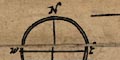
There is a compass rose. This is a simple design; a circle with N-S line and E-W cross line, marking the four cardinal points, North is marked with a fleur de lys, East By a cross.
Printed on the right is a simple compass rose, a circle with lines for the four cardinal directions, north marked by a fleur de lys, east by a cross. The map has north at the top of the page.
The map is printed with North at the top of the page.
The chart has three centres from which rhumb lines are drawn across land and sea areas; solid bold for cardinal and half cardinal directions, dotted for false points, solid light for by points. The centres are the lower three of what would be a circle of 16 centres.
Printed lower centre, at the middle of the three centres, is a north point; North marked by a fleur de lys. The map is printed with North at the top of the sheet.
At this centre there is a magnetic north line, marked by a fleur de lys, west of true North, the angle labelled:-
Variation 15d. NOie Nord Ouest.
Printed lower left is a simple compass rose aligned on the graticule; circle, star points for cardinal directions, lines for half cardinal, North marked by a fleur de lys, East by a cross. The map is printed with North at the top of the sheet.
Same as Kitchin; but tinted.
There is a compass rose with star points for the cardinal directions and lines for the half cardinal directions. North is marked by a large fleur de lys, east by a cross. Up is north on the sheet.
Printed lower left is a simple compass rose; star points for the cardinal directions, lines for the half cardinal directions, North marked by a fleur de lys. The map is printed with North at the top.
Printed lower right is a compass rose; circles, star points for cardinal directions, lines for half cardinal, North marked by a fleur de lys; East marked by a cross. The map is printed with North at the top of the sheet (towards the spine of the book).
Each column has a north point; N-S line, North marked by a fleur de lys, E-W cross line, East marked by a cross. Up on the page is the destination of the route; the column is read from bottom to top as you go.
Printed left of centre is a small compass rose; circle, star points for cardinal directions, lines for half cardinal directions, North marked by a fleur de lys, East marked by a cross. The map is printed with North at the top of the sheet.
Printed lower right is a plain compass rose; star points for the cardinal directions, lines for the half cardinal, North marked by a fleur de lys, east by a cross. The map is printed with North at the top of the page.
The canal runs north-south; it is printed on a wide sheet with East at the top of the page. There is a simple compass rose printed centrally; star points for the cardinal directions, lines for the half cardinal directions, North marked by a fleur de lys.
From my own experience I note that a tall and thin canal map, which for this canal would put North at the top, has the advantage of giving more space for place name and other labels.
The map's orientation is indicated by the latitude and longitude scales, but also by a north point aligned on the graticule, lower left; North marked by a fleur de lys, East by a cross. The map is printed with North at the top of the sheet.
The map has no compass rose or north point. It is printed with North at the top of the sheet.
Each scroll of the strip map has a north point; N-S line, E-W line, North marked by a fleur de lys, east marked by a cross. Each scroll is printed showing a stretch of road from bottom to top.
A minimal compass rose is printed lower right. There are lines for the cardinal directions in a plain circle; North marked by a half fleur de lys. The map is printed with North at the top approximately, it's about NNW up. The canal runs roughly east-west across the wide sheet.
Printed on the left, in the English Channel, is a compass rose; no circle, star points for cardinal, half cardinal, and false points, lines for by points, North marked by a fleur de lys. The map is printed with North at the top of the sheet.
Rhumb lines are drawn across sea areas from the compass rose and four other centres; bold solid lines for cardinal and half cardinal directions, dotted lines for false points, solid lines for by points. The centres are not arranged in any circle; the crossings of rhumb lines can be confusing in places.
At one of the centres, south of Wight, the vertical North line is labelled:-
True NorthA line to the west, left, is labelled:-
Magnetic Meridianand the angle labelled:-
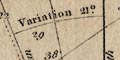
Variation 21[d].(I would take issue with the word meridian.)
The map has a north point; a line marked with a fleur de lys for north. North is up on the sheet. Magnetic north i shown by a line with a half fleur de lys, the angle is labelled:-
Von. 23[degrees] 30[minutes] N.O.There are no rhumb lines over the chart. Leading lines are labelled with their headings, eg:-
E. 1/4 N. 8[degrees] N.
N.E. 1/4 N. 5[degrees] N.
(page 103/104 scroll 3 mile 62-63)The orientation of each strip is given by a north point; NS line and an EW line, North marked by a spear point, East marked by a cross.
The strips read upwards away from London. For the London to Southampton route from Bagshot up the sheet is south and south west, from Southampton to Salisbury up the sheet is north west.
The map has a north point; N marked by a fleur de lys. And has rhumb lines drawn from five centres. It is printed with East at the top of the sheet.
The map has a simple compass rose; a plain circle with lines for the cardinal directions, north marked by a fleur de lys, east by a cross, and dotted lines for the half cardinal directions.
Printed lower right is a simple cartouche laid across the compass rose a device that John Cary uses elsewhere. The map title is:-
HAMPSHIREBelow the compass rose is:-
By JOHN CARY, Engraver.Printed at the bottom is:-
London Published Jan 1st. 1793 by J. Cary, Engraver & Mapseller, StrandThe compass rose has no circle. It has star points for the cardinal and half cardinal directions, and lines for the false points. North is marked by a fleur de lys.
Printed on the right is a compass rose; circle, star points for cardinal directions, lines for half cardinal directions, North marked by a fleur de lys. The map is printed with North at the top of the sheet.
The map has a compass rose with star points for cardinal and half cardinal points, and lines for the false points. North is marked by a fleur de lys; east is marked by an informal symbol. Map north is up on the sheet.
The map is printed with North at the top of the sheet.
The map has no compass rose or north point. It is orientated with north at the top.
The map has a north point with a cross line. North is marked by a fleur de lys; the other cardinal points are labelled 'E', 'S', 'W'.
The map has a north point with a cross line. North is marked by a fleur de lys; the other cardinal points are labelled 'E', 'S', 'W'.
The map has no compass rose, though it has latitude and longitude scales. It is printed with North at the top of the page.
The map has no indicator of orientation except the scales of latitude and longitude. The map is printed with North at the top of the sheet.
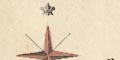
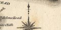
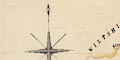
Printed lower right is a compass rose; star points for the cardinal and half cardinal directions, north marked by the Prince of Wales's Feathers. The map is printed with north at the top of the sheet.
A primary compass rose is drawn lower centre in the sea south of the Isle of Wight. This rose has a star of pointers for the cardinal and half cardinal points, extended by bearing lines over the whole sea area - missing the land but continued in the Solent etc. There are dotted lines from the rose for the false points, and continuous lines for the by points; similarly extended. North is indicated by a fleur de lys, and is labelled:-
MAGNETIC NORTH / or North by the CompassThe compass rose is oriented for magnetic, compass, north. True north is shown by a line marked with half a fleur de lys, labelled:-
True NorthThe arc of the angle between true and compass north is labelled:-
Varn. 2 1/4 Pts. W.The variation is
2.25x(360/32)=25.3125 degreesA 'point' is a by point, an 1/32nd of a circle.
There are secondary compass roses drawn in the sea east and west of the Isle of Wight. These just haave lines; bold for cardinal and half cardinal directions, dotted for false points, light for by points; all extended over the sea areas. On each, magnetic north is marked by a fleur de lys, and labelled:-
North by CompassTrue north is shown as before, and labelled:-
North of the WorldThe magnetic variation is labelled as before.
Printed lower right (with the scale line) are a pair of north points. There is a vertical line with the right half of a fleur de lys marking North, labelled:-
Meridianand a line 23 1/4 degrees West of North labelled:- Magnetic North. The chart is printed with 'true' north at the top of the sheet.
The map has a very simple compass rose upper left of centre. There are lines for the cardinal directions in a double circle; north marked by a fleur de lys, east by a cross.
Printed lower right of centre is a north point; or rather two north points, each with half a fleur de lys, with the magnetic deviation:-
Varn. 23[degree] W.between them. Up the page is current magnetic north.
The map is printed with North at the top of the sheet.
The map is printed with North at the top of the page. There is no compass rose or north point.
Printed upper left is a compass rose; star points for the cardinal directions, lines for the half cardinal directions, north marked by a fleur de lys. The map is printed with north at the top of the page.
Printed upper left is a north point; north marked by a fleur de lys, a cross line E-W. The north point is upside down, pointing south.
Orientation is provided by a simple cross line, north marked by a spear point. The map is arranged 'up is out from London'; London is at the bottom, Portsmouth at the top of plate 3, London at the bottom, Salisbury at the top of plate 5.
Printed lower right is a compass rose; no circle, star points for cardinal and half cardinal directions, North marked by a fleur de lys. The map is printed with North at the top of the sheet.
The map is printed with North at the top of the page. There is no compass rose or other indicator.
Although the maps are printed with North at the top of the sheet, this 'up' is at a small angle to 'up' of the modern Ordnance Survey sheets.
The map has no compass rose or north point; it is printed with North at the top of the page.
Printed lower right is a compass rose; no circle, star points for cardinal and half cardinal directions, North marked by a fleur de lys. The map is printed with North at the top of the page.
There is no indicator of orientation except the latitude and longitude scales. The map is printed with North at the top of the sheet.
This is a thematic map for which orientation, scale, and coordinates are of little interest.
There is no compass rose or other indicator of orientation. The map is printed with North at the top of the page.
Printed upper left is a compass rose; no circle, star points for cardinal and half cardinal directions, North marked by a fleur de lys. The map is printed with North at the top of the sheet.
Printed upper right of centre is a compass rose. The map is printed with North at the top.
The map is printed with North at the top of the sheet.
Printed upper right is a compass rose; no circle, star points for cardinal and half cardinal directions, North marked by a fleur de lys. The map is printed with North at the top of the sheet.
Printed upper left is a compass rose; tinted red or pink, no circle, star points for the cardinal directions, lines for the half cardinal, North marked by a fleur de lys. The map is printed with North at the top of the page.
Printed in a space in the Irish Sea is a compass rose; no circle, star points for cardinal and half cardinal directions, lines for false points, North marked by a fleur de lys. The map is printed with North at the top of the page.
Printed lower right is a compass rose; star points for the cardinal and half cardinal points, lines for the false points, North marked by a sort of arrowhead. The map is printed with North at the top of the sheet.
The map has north at the top of the sheets.
Printed on the right is a compass rose; no circle, star points for cardinal, half cardinal, and false points, lines for bye points, North marked by a fleur de lys. The map is printed with North at the top of the sheets.

Printed upper centre is a compass rose; no circle, star points for cardinal and half cardinal directions, North marked by a fleur de lys. The map is printed with North at the top of the sheet.
There is no compass rose. The map is printed with North at the top of the sheet.
The map's orientation is 'obvious'. The map is printed with North at the top of the sheet.
Printed on the left above centre is a compass rose; no circle, star points for cardinal and half cardinal directions, North marked by a fleur de lys. The map is printed with North at the top of the sheet.
Printed upper right is a compass rose; no circle, star points for cardinal and half cardinal directions, North marked by a fleur de lys. The map is printed with North at the top of the sheet.

Printed on the left is a compass rose; star points for cardinal, half cardinal and false points, North marked by a fleur de lys. The map is printed with North at the top of the sheet.
Orientation is shown by a north point; N-S line, E-W cross line, North is marked by a fleur de lys, the other cardinal points are labelled - E, S, W. The map is printed with North at the top of the sheet, sort of.
BUT the map is so distorted that the orientation is of questionable value. It is stretched on a NW-SE axis and rotated some. It is quite the worst map of Hampshire I've come across - unless it is a completely unrecognised projection! Using a computer graphics program we have tried 'undistorting' the map by linear transformations. Two transformations have been tried; bringing four perimeter towns into alignment with where they 'should' be, and matching the county boundary to 'today's real' boundary. Both processes have there limitations. Both processes leave most of the towns well out of position. I do not believe there is an projection in use which we have failed to recognise.
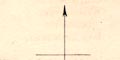
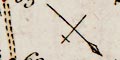
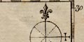
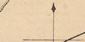
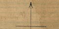
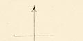
Printed on the left above centre is a simple north point; N-S line, E-W line, North marked by an arrow.
Printed lower right is a north point; and an E-W line, N marked by an arrow and a cross (X). The map is printed with North at the top of the page.
Printed on the left is a compass rose; no circle, star points for cardinal and half cardinal directions, North marked by a fleur de lys. The map is printed with North at the top of the sheet.
Printed upper right is a north point; N-S line, E-W cross line, North marked by an arrowhead. The map is printed with North at the top of the sheet.
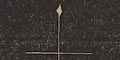
Printed lower right is a north point, N-S line, E-W cross line, North marked by a spear point. The map is printed with North at the top of the sheet.
Printed upper right is a compass rose; no circle, star points for cardinal and half cardinal directions, lines for the false points, North marked by a fleur de lys. The map is printed with North at the top of the page.
Printed lower left is a north pint; N-S line with an arrow marking North, E-W cross line. The map is printed with North at the top of the sheet.
Printed upper left is a north point; N-S line; E-W cross line; North marked by a fleur de lys. The map is printed with North at the top of the sheet.
The map has north at the top.
Printed on the left is a compass rose; no circle, star points for the cardinal and half cardinal directions, North marked by a fleur de lys. The map is printed with North at the top of the page.
Printed lower right on the south sheet is a north point; N-S line, North marked by an arrow; E-W cross line. The maps are printed with North at the top of the sheets.
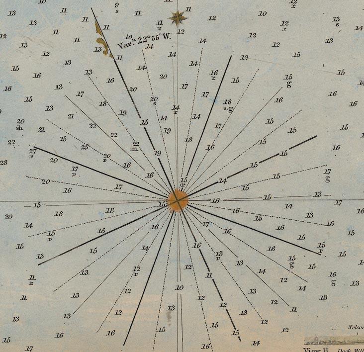
Printed lower left of centre and lower right are compass roses showing magnetic directions; no circle, bold lines for cardinal and half cardinal directions, lines for false points, dotted lines for by points, magnetic North marked by a half fleur de lys. The meridian through the rose is marked with a star, and the angle between the meridian and magnetic north labelled:-
Varn. 22 [degrees] 55 [minutes] W.at 1d 5m W, and:-
Varn. 22 [degrees] 40 [minutes] W.at 0d 40m W.
The chart is printed with [geographical] North at the top of the sheet. The centre of the rose, the fleur de lys, and the star are tinted orange.
Up on the page is north.
Printed upper left is a north point; N-S line; North marked by a fleur de lys; E-W cross line. The map is printed with north at the top of the sheet.
The direction of travel is down the page, ie London is at the top, Southampton at the bottom. The traveller is advised to sit facing towards London, ie facing up the page, while he reads in the natural way down the page ... it makes good sense.
There are no clues to compass direction on the chart.
Printed upper right is a compass rose; no circle, decorated lines for cardinal and half cardinal points, North marked by a fleur de lys. The map is printed with North at the top of the sheet.
The map is printed with North at the top of the page. There is no compass rose or north point.
Printed upper left is a compass rose; no circle, decorated lines for cardinal and half cardinal directions, North marked by an arrow. The map is printed with North at the top of the sheet.
The map is printed with North at the top of the sheet.
The map has no indicator of orientation except the graticule, the latitude and longitude grid. The map is printed with North at the top of the sheet.
Printed on the left is a compass rose; no circle, star points and lines for the cardinal and half cardinal directions, lines for the false points, North marked by an arrowhead (a sort of exploded fleur de lys). The map is printed with North at the top of the page.
Each map has a north point (or very simplified compass rose); N-S line, E-W cross line, short lines for the half cardinal directions, North marked by an arrow.
The orientation of each map is suited to the length of railway shown; start of the segment at the top, finish at the bottom. In practical terms this puts NE or NW at the top of a map. Up is judged by the labelling. One of the maps is printed sideways on the sheet to get it fitted in.
Printed on the right is a north point with an E-W cross line; North marked by an arrow. The map is printed with North at the top of the sheet.
Printed upper left below the title is a north point; N-S line, North marked by an arrow, and E-W cross line.
Printed upper right is a compass rose; no circle, star points for cardinal and half cardinal directions, North marked by a fleur de lys. The map is printed with North at the top of the sheet.
The maps are printed with North at the top of the sheet.
The map's orientation is indicated only by the latitude and longitude scales and grid. The map is printed with North at the top of the sheet.
The map has north at the top of the page; there is no north point.
The map has no compass rose, it is printed with North at the top of the sheet.
The map has no indicator of orientation, it is printed with North at the top of the sheet.
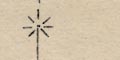
Printed upper right is a north point; N-S line, E-W cross line, North marked by a 'star' of 8 radiating lines. The map is printed with North at the top of the sheet.
Printed upper right is a compass rose; no circle, star points for cardinal and half cardinal directions, lines for false points, North marked by a fleur de lys. The map is printed with North at the top of the sheet.
The map has no compass rose; it is printed with north at the top of the page as it is meant to be read. For Hampshire this is sideways, other maps are printed the other way on the double page spread, suiting their shape to the space.
The map is carved with North at the top of the slab.
Printed left of centre is a compass rose; no circle, star points for cardinal and half cardinal directions, North marked by a fleur de lys. The map is printed with North at the top of the sheet.
The map has no compass rose or latitude and longitude scales. It is printed with north at the top of the page.
The map has no north indicator except the scales for latitude and longitude; it is printed with North at the top of the page. The fold of the sheet, running E-W across the map, suggests it was sideways in its atlas.
Nearly all circle maps have a north point; a N-S line with a short E-W line, North marked by a simple arrow. The circles and route in between are printed with the destination at the top of the sheet. The return journey alongside is up the other way; its text up the other way.
The map is presented on the slant, up is NNW, so that the route, London to Exeter, is down the middle of the long map.
The map is printed with North at the top of the sheet.
The maps are printed with North at the top of each sheet,as defined by the label text. Some sheets are printed in 'landscape' and some in 'portrait' on the sheet.
Printed half way up the side is a minimal compass rose; no circle, lines for cardinal and half cardinal directions, North marked by an arrow head, labels N, E, W. The map is printed with the destination at the top of the sheet; SW at the top.
The map has no indicator of orientation; it is printed with North at the top of the sheet.
Printed in the [probably] upper right border of the map, or perhaps in an otherwise blank sea area, is a compass rose; no circle, decorated lines for cardinal and half cardinal directions, North marked by an arrow and fleur de lys. A magnetic north line is also given accompanied by a statement like (sheet 132):-
Magnetic Varn. 15[degrees] 44[minutes] W Jan. 1925. Annual decrease 10[minutes] (not constant)
The map has no indicator of orientation; it is printed with North at the top of the sheet.
The strip maps are drawn with the destination, away from London, at the top of the page. The line is plotted in the landscape, not straightened.
orientation |
|||||||||||||||||||||||||||||||||
| labelled borders, Latin |  |
|
|
|
|
 |
 |
|
|
 |
 |
|
|
|
|
|
|
||||||||||||||||
| labelled borders, English | |
|
|
|
|
|
|
|
|
|
|
|
|
|
|||||||||||||||||||
| compass rose | |
|
|
|
|
|
|
|
|
|
|
|
|
|
|
|
|
|
|
|
|
|
|
|
|
|
|
|
|
|
|
|
|
| N = fleur de lys | |
|
|
|
|
|
|
|
|
|
|
|
|
|
|
|
|
|
|
|
|
|
|
|
|
|
|
|
|
|
|
|
|
| N = arrow, spearhead | |
|
|
|
|
|
|
|
|
|
|
|
|
|
|
|
|
|
|
|
|||||||||||||
| N = Prince of Wales' feathers | |
|
|
|
|
||||||||||||||||||||||||||||
| E = cross | |
|
 |
|
|
|
|
|
|
|
|
|
|
|
|
|
|
|
|
|
|
|
|
|
|
||||||||
| E = 3 balls | |
|
|
|
|
|
|
|
|
|
|||||||||||||||||||||||
| points labelled, NESW | |
|
|
|
|
|
|
|
|
|
|
|
|
|
|
|
|
|
|
|
|
|
|
|
|
|
|
||||||
| points named, English | |
|
|
|
|
||||||||||||||||||||||||||||
| points named, Latin | |
|
|
|
|
|
|||||||||||||||||||||||||||
| north point | |
|
|
|
|
|
|
|
|
|
|
|
|
|
|
|
|||||||||||||||||
