
 Return to list of Features

NB: typical illustrated examples are described, NOT ALL examples.
absence of evidence is not evidence of absence
This map has no index grid. Calculations have been made to overlay the National Grid system on the map.
There is no small scale line on the map.
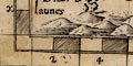
There is an overall grid of squares in the borders which are believed to be in miles, chequered at half mile intervals.
Printed at the foot of the table of hundreds it says:-
The scale of miles goeth rounde about the Mapp
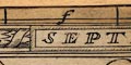
All four map borders are chequered to show miles, west-east and north-south; the origin of the scales is top left. Each two miles is labelled across top and bottom, 2, 4, 6, ... 48. The labelling on the sides runs down a, b, c, ... x (no 'i' or 'u'). Besides being scale lines the scales and the grid printed across the map in fine lines make an index grid. John Norden's provision of an index grid is an innovation in map making.
The scale can be estimated from the scale line:-
48 miles = 400.5 mmWrongly assuming a modern statute miles this gives a scale 1 to 192880; the map scale is about:-
1 to 190000
3 miles to 1 inchA better estimate of scale has been estimated from the positions of towns, also providing a value of the 'old english mile' used in Norden in 1595. The process is described in notes DISTTAB.rul accompanying software which does the sums. The map scale is about 1 to 241379, say:-
1 to 240000
4 miles to 1 inchNorden uses an:-
Old English Mile = 1.24 statute miles
This map has no index grid. Calculations have been made to overlay the National Grid system on the map.
This map has no index grid. Calculations have been made to overlay the National Grid system on the map.
This map has no index grid. Calculations have been made to overlay the National Grid system on the map.
This map has no index grid. Calculations have been made to overlay the National Grid system on the map.
Mostly as original:-The picture frame border of the map is unchanged but for the addition of gradations and labelling for an index grid to the map. This idea did not come from Speed; Norden had an index grid, but not quite like this.
On the upper border are marks at 1 inch spacing, the intervals labelled a..m (no j); 12 divisions. The marks do not start at the edge of the map, but are arranged to encompass the width of Hampshire. The spacing is not simply related to the map miles on the scale line. Down the left border are similar marks and labelling. And again, the scale does not start at the edge of the map, but does encompass the height of the county area. The index grid is not drawn across the map (which is already full of detail).
Although the grid is not drawn across the map there are letters a..m across the top and a..n down the side, for indexing the county area.
The map has a rectangular index grid; labelled A.. across the bottom, a.. down the sides. (The scales in the borders are numbered as well, for what?)
This map has no index grid. Calculations have been made to overlay the National Grid system on the map.
This map has no index grid. Calculations have been made to overlay the National Grid system on the map.
This map has no index grid. Calculations have been made to overlay the National Grid system on the map.
This map has no index grid. Calculations have been made to overlay the National Grid system on the map.
The national grid coordinate system has been laid over the map (this sectioned version with gaps) using some elementary arithmetic, aided by software for the calculations.
This map has no index grid. Calculations have been made to overlay the National Grid system on the map.
This map has no index grid. Calculations have been made to overlay the National Grid system on the map.
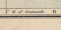
The map has a graticule, latitude and longitude grid, printed at 10 minute intervals, for a trapezoid projection. The grid is labelled in the borders at 10 minute intervals. The ratio of the longitude scales top/bottom is 1.01; this is close to the 'correct' value, 1.02, for the latitude range. The ratio of latitude to longitude scales is 1.58, exactly the value for a 'square' map. The graduations at the bottom, longitude, are labelled:-
W. from GreenwichThe
longitude, Winchester = 1d 18.5m Wwhich accords with the Greenwich prime meridian.
The map includes from 0d 45m to 1d 55m W, from 50d 30m to 51d 25m N; the whole of Hampshire and the Isle of Wight. Odd corners of the county stick out beyond the borders of the map.
The borders also have labels for the graticule cells; A..H from left to right and 1..6 from top to bottom, so the graticule can be used as a simpler index grid.
Printed across the map is a grid, this is not a graticule of latitude and longitude. The grid is rectangular and divides the map into 20 cells, 4 across 5 down. The cells are labelled in the borders; A..D, a..e, making this a simple index grid for referring to positions on the map. The cells are large; given a reference there is still a lot of searching to do to find a place on this crowded map.
There is a rectangular latitude and longitude grid, a graticule, printed over the map, at 10 minute intervals, labelled in the borders at 30 minute intervals. The longitude of Winchester is 1 degree 18 1/2 minutes W corresponding to a prime meridian at Greenwich (accepted internationally 1884).
The map covers 0 degree 45 minutes to 1 degree 55 minutes W, 50 degrees 30 minutes to 51 degrees 30 minutes N; Hampshire including the Christchurch area, now Dorset, and the Isle of Wight.
The graticule also serves as an index grid. The 10x10 minute cells are labelled in the borders A..H top to bottom, 1..6 left to right. These are referred to by the:-
INDEXat the back of the atlas, where:-
NOTE,- The letters and numbers after the names correspond with those in the borders of the map, and indicate the square in which the name will be found.For example:-
Winchester, Hampshire ... D 3in which square you will find the word though the town symbol is in E3.
At the upper right there is a printed explanation of the grid printed on the map, which is not latitude and longitude, though it must be closely related. The:-
Black Lines refer to the Lamplighting Tables.
Find the Town or District required on the Map, and add or deduct the number of minutes from Column A to I given in the Lamplighting Tables at the beginning of the book, on the date required.
Example: Coventry is in Column 6F, therefore add 6 minutes to Column F on all dates.A label at the bottom states:-
MINUTES TO BE ADDED TO COLUMNS A-I.and to the east of the meridian, '... subtracted ...' The columns are numbered 0, 2, 4, 6 either way from the Greenwich meridian; rows are labelled from A in the north to I in the south. Hampshire lies in H..I, 2..8. The:-
LAMPLIGHTING TABLES. For the Different Districts, to be used along with the Map at the end of the volume. are near the front of the booklet. The entries are include under H:-
[Nov] 26 ... ... 4.52 ...So for Winchester, in row H, column 4-6, lighting up time on 28 November would be between 4.56 and 4.58.
Our sophistication with road use, and the need for vehicle lights, has increased to a level where good sense tends to prevail nowadays, without the need to consult published tables.
Printed in the map borders are scales of latitude and longitude for a conical projection; chequered at 10 minute intervals, labelled at 30 minute intervals. The map includes from 1d 40m E to 5d 40m W, from 49d 5m to 52d 30m N; plus an inset map for the Scilly Isles.
A graticule, latitude and longitude grid, is printed at 30 minute intervals. This grid is also an index grid. Its 'squares' are labelled A..O (no J) across, h..o (no j) down. The north sheet presumably has a..h.
An index grid is printed across the map; cells 1..14 across, the 14th cell is half size; cells A..J downwards, not including I. The cell size is 3520 yards square; it does not correspond to the lat and long scales in any obvious way.
Johnston 1920, questions after his paper, Col Whitlock:-
... The new one-inch popular edition is squared wih two-inch squares. This enables anyone to judge distances pretty accurately. ...It isn't really an index grid at all?
The map borders are marked to divide the map's area in 24 cells, 4 across by 6 on the sides; labelled A..D across, 1..6 down. The letter number references are used in a gazetteer on the reverse of the map card.
Adjacent cards are indicated by red labelling around the map border. On card 6, on the left:-
Continuation Map 7 / Continuation Map 10at the top:-
Continuation Map 10 / Continuation Map 5on the right:-
Continuation Map 3
