
 Return to list of Features

NB: typical illustrated examples are described, NOT ALL examples.
absence of evidence is not evidence of absence
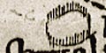
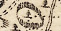
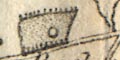
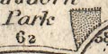
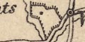
Parks are shown by a ring of fence palings. The park might contain a settlement symbol; it is difficult to know when this indicates a hamlet or village, and when just the house in the park. Most parks are drawn roughly circular, but there are a couple of oddities, that near Clanfield, for example. Some parks are labelled.
Parks are not obviously shown on this general map of the country. Though in Hampshire:-
The Vineis labelled. This house was the seat of one of the politically influential lords of Elizabeth's court.
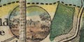
The land is decorated, vastly out of scale, with perspective drawings of parks, great houses, etc. There is a large ?sheep in Dorset, and some ?cattle in Sussex.
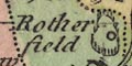
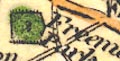
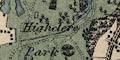
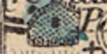
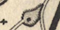
Parks are shown by a ring of fence palings, shaded to the east. Many of these have a house symbol inside, and might include a tree or more. The house or park might be labelled, eg:-
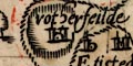
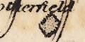
rotherfeilde
parke
pkeTrees are placed in parks with some thought, not just decoratively:-
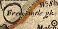
fremantle pk
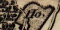
Parks are shown by a fence of palings in a ring; there are several examples around Basingstoke.
Most parks can be identified, and some are lebelled, eg:-
Fremantle pk
Barne pkwhich is Beaurepaire Park
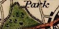
Parks are shown by a ring of fence palings. Some have trees, and perhaps a settlement within. The park may be labelled, eg:-
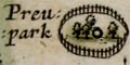
Preupark
Parke
Parks are drawn by a ring of fence palings, shaded to the right, which is to the north. The park might enclose a settlement or house, and perhaps trees which are tinted green. The park or house might be labelled, eg:-
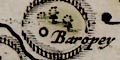
Baropey
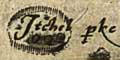
Titchfeild house
Grove placeTitchfield Park is a double park, with the northern part wooded.
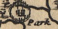
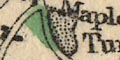
Parks are shown by a ring of fence palings. Some contain trees. Few are labelled except by the house or settlement within or near.
Parks are drawn by a ring of fence palings. At least one is labelled:-
Parksouth of Lyndhurst. A lot of parks are not drawn. The fences are in need of repair.
Mostly as original:-An unlabelled park is added, recognisable as Pylewell Park; and a house nearby, labelled:-
Park houseA label without a park is added:-
Prew pke.
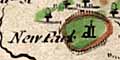
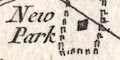
Parks are shown by a ring of palings. Emparkment is formal, a privelege granted by the crown; many of the parks shown on early maps were emparked in the 12th to 14th centuries. Some are labelled, eg:-
New Park
Fremantle park
Baropethe latter is Beaurepaire Park. Most parks are not labelled but can be identified, give a bit of effort.
Parks are shown by a small ring of fence palings, for example at Hursley.
Parks are shown by a ring of paling fence. Few are named, eg:-
New Parkin the New Forest, where the engraver has forgotten the fence palings. And:-
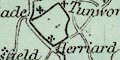
Southwikewhich is named by its house or hamlet.
A number of parks are drawn on the map, perhaps fewer than earlier maps. They are mostly shown by their boundary of a paling fence in perspective, the shapes and sizes different. Some are named, eg:-
New Parkin the New Forest, which, like Marwell Park, lacks its fence palings. This 'error' is copied from an earlier map.
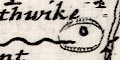
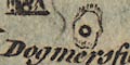
A park might be named by an included settlement or house, eg:-
Dogmersfield
Some parks are depicted by a boundary containing a few trees. No attempt is made to show a paling fence. Parks are not labelled.
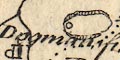
Parks are not a prominent feature of the map. A couple are drawn by a ring of paling fence, named by the hamlet enclosed:-
Dogmersfield
FarnboroughAnd named directly:-
N Parkis drawn as a hamlet, no fence, within the New Forest.
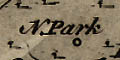
Very few parks are shown on this map. A vague circle of fence palings indicates a park at Dogmersfield and at Farnborough, the name
N Parklabels a ?settlement near Beaulieu, this is New Park.
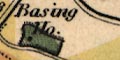
Parks are shown by a ring of fence palings on an outline; the outline shape and size is meant to be a little realistic. Some parks are labelled by the house marked within the pale, eg:-
Basing HouseSome are named, eg:-
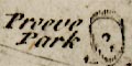
Preeve Park
Tremanton ParkOthers are not named. Some are drawn very indistinctly: look carefully, eg:-
Parks are drawn by a ring of paling fence. None are labelled.
Parks are drawn in outline by a ring of fence palings. Or rather by Bellin's interpretation of fence palings as a ring of ?standing stones. The are might be labelled, eg:-
Parc
Parck
Parc et Maisonor more helpfully, eg:-
New Park [near Lyndhurst]
Parc de Stainsteadwhich contains a large house, roads, and trees labelled:-
Forest de StainsteadNotice the double park at Titchfield, which is correct.
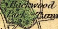
Parks are drawn by a ring of fence palings, perhaps containing a tree, or circle for a house. The outline shape has some pretence to reality. The park might be labelled, perhaps by a house name, eg:-
Burley Lodge
Freemantle Park
Hackwood ParkPrinted on the right is a list of:-
Seats of Nobility &c.listing two dozen persons, who were perhaps subscribers to the atlas?
Much the same as Kitchin; interiors tinted. There might be differences of interior detail.
Parks are the same shape, an outline with fence palings. On the Bowles and Sayer map Hursley Park has fewer trees, and is tinted.
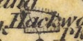
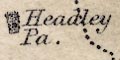
Parks are drawn by an outline with fence palings. This might contain trees and perhaps a house shown by a circle and flag symbol. The park or house might be labelled, eg:-
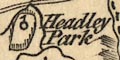
Headley Park
Hackwood Parkwhich has all those elements.
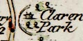
No park in Hampshire is shown on the maps studied. On other parts of the plate, near Salisbury, Wiltshire, a park is drawn by a house and a ring of fencing, labelled:-
(plate 20 scroll 2 mile 22)
Clarendon Park
Parks are drawn in outline, with fence palings, perhaps with a house or tree within, perhaps labelled by name or name of the house, eg:-
Rotherfield
Lodge Park [Hursley]
A few parks are shown by a ring of fence palings, which might enclose a tree or two, and might be labelled, eg:-
Hackwood Park
Parks are not particulary marked by any symbol, though some trees are likely, as at Broadlands for example, where they are in a neat row.
Grove Place
Broadlands
Marsh Courtare labelled. These might have lands effected by the canal?
Parks near the canal's proposed route are shown as an outline and labelled as a park or by the great house. In Hampshire are:-
Hackwood
Tylney Hall
Dogmersfield Parkand further from the canal's line:-
Heckfield Park
Elvetham Park
Bramshill Park
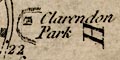
Parks are shown by a ring of fance palings, the one example is near Salisbury, Wiltshire, labelled:-
(page 103/104 scroll 6 mile 22)
Clarendon Parkwhose fence is incomplete, just the parts near the road shown.
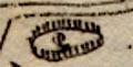
The table of symbol gives an oval of fence palings for a park. This symbol, in various shapes and sizes is found over the map. None (?) is explicitly labelled.
Parks are drawn in outline with a ring of fence palings. The park usually contains a house, and might be labelled, eg:-
Hackwood Park
Dogmersfield
Burley Lodge
Parks are shown by a ring of fence palings with a railing; round, oval or irregular shapes. Some are labelled, eg:-
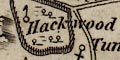
Hackwood Park
Fremantle ParkMany are not. Some have a settelement symbol within the park, a circle with a small flag, for the great house? eg:-
RotherfieldOr it might be a circle plus a cross, eg:-
Dogmersfieldor just a circle, eg:-
Moyles Court
A park might be shown as an area enclosed by a paling fence, as at:-
Bramshill ParkThe emparked area has trees and undergrowth depicted, as well as dot and circle with two towers, for the house. Grander features, like the avenue mentioned above, may be drawn. Other parks might be labelled by their house name, eg:-
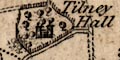
Tilney Hall
Parks might be drawn in outline, pecked inside, perhaps with a house, and perhaps labelled, eg:-
Bedhampton Parkon a hill north of Havant. Some parks have vestigial fence palings around the outline, eg:-
Southwick Park
Roch Court
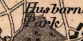
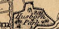
Parks are shown by a ring of fence palings enclosing a pecked area. The great house within, a Gentleman's Seat, has its own symbol, a small square. Either house or park might be labelled, eg;-
Husborne Park
Iver LodgeA seat may not have a park drawn round it.
Parks are shown in outline with fence palings; the interior pecked. There might be a block for a house, and might be some trees, for example by Alresford.
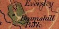
Parks are drawn in outline with fence palings round the boundary. The interior is tinted, on our map, and might show the great house, access roads, wooded avenues, etc. The park itself might be named, or its house, eg:-
Bramshill Park
Dogmersfield
Tilney HallSome parks have interesting detail. Bramshill is a nice example, having avenues of trees on its access roads, continued out into Eversley Common on the east.
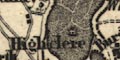
Not all the parks are the old emparked estates; Tilney for one os newer. There are other seats which are marked by a house symbol without a park, eg:-
Rodenham
Parks are drawn by an outline of paling fence with a position circle inside. The park area is tinted. Some parks are named, eg:-
New Park
Headley Park
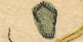
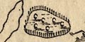
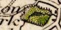
A very few parks, just 5, are drawn by a ring of paling fence with the interior coloured green. None are labelled.
Parks are shown by a bounded area of dotted ground with some trees, and tinted green. The boundary line has vestiges of fence palings. Parks might be labelled, in some cases difficult to distinguish from a nearby settlement, eg at Hursley, but see:-
Freemantle Park
Dogmersfield
Harewood Park
Idesworth
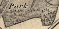
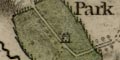
At this scale parks are shown in some detail, for example:-
Bramshill Park :-
Outline with fence palings, trees and avenues, ponds, house, roads, etc.
Hackwood Park :-
Parkland, formal rides, house, lodge, roads, etc.
Hurstbourne House :-
Hills, lakes, house, trees and avenues, statue, keepers lodge, etc.
Parks are drawn by an outline with a vestigial fringe of fence palings. They generally enclose some trees and are tinted green. A few are labelled, eg:-
Hackwood Park
Freemantle Pa.
Parks are drawn in outline with fence palings, and a pecked interior. Some are named, or their house is named, eg:-
Husborn Park
Hackwood Park
Ashley Lodge
Parks are drawn in outline with fence palings, the interior dotted, perhaps with a tree or two. Some parks are labelled, eg:-
Hackwood Park
Marwell
Cadland Park
Parks are drawn in outline, with fence palings around, a pecked interior tinted green, and perhaps trees, etc. Parks might be labelled with a name or the name of a house, eg:-
Hackwood Park
Husbourne Park
Cranbury Hou.
West Lodge
At Hambledon the Park House is outside the park.
Parks are shown in outline with the interior pecked. If you look closely you can see fence palings on the outline. A few parks are labelled, eg:-
Hackwood Pk.
New Park [New Forest]
Chawton Park
Parks are shown by a ring of fence palings, just little upright lines, round a stippled area. The shape and size of these areas vary, perhaps trying to be realistic. Some are labelled:-
Husborn Park
Heckfield Pa.
Southwick P.
Parks are drawn in outline with fence palings, and perhaps ?ornamental trees, the interior dotted and tinted green. The interior might show a great house, roads or rides, woodland, ponds, streams, etc. A park might be labelled with a name, or by the name of its house, eg:-
Highclere Park
The Vine
Heckfield House
Stratfield Park
Parks are shown as areas with a suggestion of a paling fence around them. The areas vary in shape. Highclere Park is drawn big enough to have rides within the grounds drawn in plan. The big house within the park may be shown by a square. Some parks are labelled, eg:-
Highclere
Rotherfield PaAnd the confusion between park and settlement might be clarified as:-
Herriard & Pa
Parks are shown by a suggestion of a ring of fence palings, the true shape of the park being attempted? Some parks have been tinted, green, and some contain tree symbols. Example:-
Husborne Parkin which there are drives among the trees.
A very few parks are drawn in outline with fence palings, not labelled.
Parks are drawn in outline; the interior pecked, perhaps with a block for a house, and fence palings. Some are labelled by name or by the name of a house, eg:-
Bolderwood Lo.
Cadland Pa.
Highclere Park
Clare H.The interior is tinted green on this copy of the map.
A few parks are drawn by an outline with fence palings, the interior dotted, and perhaps having a block for a house. Some are labelled, eg:-
Hackwood Park
Basing Pa. [near Filmer Hill]
It is not clear, but a few patches of 'dotting' are probably meant to represent parks. A less doubtful example by Odiham is most likely Dogmersfield Park.
Parks are drawn in outline with vestigial fence palings. The interior is pecked and might have a building block, pond, etc. The parks shown include modern creations, eg:-
Rose Hill Pa.south east of Malwood, as well as older parks, eg:-
Hockwood Park [Hackwood]Some parks are labelled by their house, eg:-
Basing Ho. [SW of Colemere]
Some parks are drawn in outline with fence palings, the interior pecked and tinted green. Some are labelled, eg:-
Hackwood P.
Rosehill Parkor have a house name, eg:-
Dogmersfield Ho.
Some parks are drawn in outline, with a pecked interior. None appear to be labelled.
A number of parks are shown in outline, with a suggestion of fence plaings. The areas are tinted green, but the tinting of the whole map is poorly done, parks are most slap dash. Parks include modern estates as well as some of the old emparked areas, and are mostly [all?] unlabelled.
Parks are drawn as a dotted area enclosed by a line with vestigial fence palings; there may be a little tree symbol or two. The park may be labelled, eg:-
Paulton Park
Bramshill Parkor are named by a house, eg:-
Hawley Ho.
Redenham Ho.but may or may not be a formally emparked area.
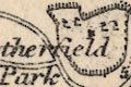
Some parks are drawn by an outline with a pecked interior, which mght be labelled, eg:-
Rotherfield ParkHackwood Park is larger and contains ?tree symbols. Some parks have a dot for a house.
Parks are drawn in outline with fence palings, their interior pecked. They might be unlabelled, might have a block for a house, or might be labelled, eg:-
Hodwood Park [Hackwood]or by the house name, eg:-
Basing Ho.near 'Floxfield' ie Froxfield.
Parks are shown by a line enclosing an area of trees etc, coloured green. Only some parks are labelled, eg:-
Bramshill Park
Warnborugh Park [sic]Some of these areas are woodland enclosures, nuut these are usually not coloured
Parks are not infrequent in the names of meeting places of the hunt, eg:-
Brookwood Park
Some parks are drawn by a ring of fence palings with a pecked interior fill. Hardly any are labelled? but see:-
Bisley Parkon the north east border.
The table of symbols refers to 'seats' and the areas shown by an outline with fence palings filled with woodland or just pecked, are recent as well as old parkland. These might be labelled with a park name, or a house name, eg:-
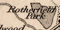
Rotherfield Park
Pelham Place [near Rotherfield]
Parks are drawn as an outline with a pecked interior, mostly tinted green. Most are not named, but see:_
Stratfield Sayelabelling the vignette scene beside the park outline.
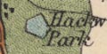
Parks are drawn by an outline with upright fence palings. These include more than the ancient formally emparked areas. Most of the parks enclose a house; some have trees and other vegetation. Their shapes and sizes attempt to represent the extent of the estate. Labelling is in lowercase italic text, eg:-
Husborn Park
Bramshill Park
Tangier
Parks are drawn in outline, the interior pecked and tinted green. The park might enclose buildings, roads, ponds, rivers, trees, etc. Some parks are labelled by name or the name of its house, eg:-
Hackwood Park
Bramshill Park
Dogmersfield Ho.
Parks are drawn in outline with a pecked interior; no hint of fence palings. Many are labelled, eg:-
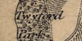
Twyford Park
Cadland Parkas well as the more ancient:-
Hackwood Park
Dogmersfield ParkThe park may contain house, roads, ponds, etc, for example at Highclere, whereis:-
Highclere Castleand:-
in each case the house labelling the park.
Some parks are drawn in outline, the interior dotted, perhaps marked with roads or drives, and a building. A park might be labelled by name, or name of its house, eg:-
Dogmersfield Park
Tilney Hall
Hackwood Park
A few parks are drawn in outline filled with trees, bushes, etc. These might be labelled with a park name, or house name, eg:-
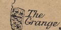
The Grange [N of New Alresford]
Brockenhurst Park
Hursley Park
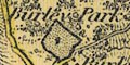
A few parks are drawn in outline (no fence palings). For example near Northington and near Herriard.
parks are drawn in outline with fence palings, the interior dotted, and a dot for the great house. Many parks are labelled, by name or name of their house, eg:-
Hackwood Park
Stratton Park
Ashurst Lodge
Tilney Hall
Parks are drawn in outline with dotted interior, and perhaps rides and a house, etc. They might be labelled by name or name of their great house, eg:-
Hackwood Park
Tilney Hall
Rotherfield Ho. and Park
Some parks are drawn in outline, perhaps labelled, eg:-
Hackwood Park
Parks are shown by an outline with a pecked filling, perhaps with a dot for the big house. The parks are not just the old, formally emparked areas, but also the newer estates. Examples:-
Cadland Park
Eaglehurst
Hackwood Park
A couple of parks are drawn in outline, labelled:-
Hackwood Pk.
Emley Park
Parks might be drawn in outline, with a pecked interior, and perhaps other features. A park might be labelled with a name or a house name, eg:-
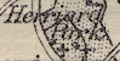
Herriard Park
Dogmersfield Ho
parks are drawn in outline, the interior pecked, perhaps having a few trees, perhaps labelled, eg:-
Burley Park
Hackwood Parkperhaps labelled by the house name, eg:-
The Vine
Some parks are shown, perhaps in outline with a pecked interior, or just labelled, eg:-
Hackwood Park
Cadland Parkperhaps named by the house in the park:-
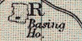
Basing Ho.
Parks are drawn in outline, pecked and tinted green. They might be labelled, eg:-
Hurstbourne Park
Parks are drawn in outline, the interior dotted, and might have trees, house, pond, etc. There is a nice example, unlabelled, near Wymering. A park might be labelled by name, or by the name of its house, eg:-
IDSWORTH Ho.
PURBROOK PARK
Parks are shown in outline, with a green ground, and detail of house, ornamental drives, areas of woodland, etc. The park or its house might be labelled, eg:-
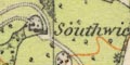
Southwick Ho.Parks are no longer very significant.
Bilikowski, K: 1983: Historic Parks and Gardens: Hampshire CC (Winchester, Hampshire):: ISBN 0 900908 7 93
Roberts, Edward: 1988: Bishop of Winchester's Deer Parks in Hampshire, 1200-1400: ProcHFC: vol.44: pp.67-86
