
| Map features
Blaeu's Hampshire 1645
|
|
| Map feature
|
Some images can be clicked for more information.
|

|
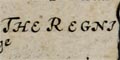
title cartouche; strapwork; 'HANTONIA SIVE
SOUTHANTONIENSIS COMITATUS Vulgo HANTSHIRE.'
|

|
coat of arms; royal coat of arms, and of earls of Winchester
and Southampton.
|
|
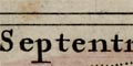
orientation; labelled borders; 'Septentrio' etc.
|
|
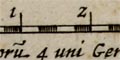
scale line; 'Mill. Angl. quoru~ 4 uni Germanico aequip'.
|
|
coast shaded; into a plain sea, sandbanks or mudflats
shown; the sea busy with ships.
|
|
rivers; wiggly lines narrowing upstream.
|
|
bridges; some bridges are clearly marked.
|

|
relief; groups of hillocks shaded on the east side.
|
|
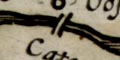
beacons; post or posts on a hillock.
|

|
woods, forests; groups of small trees with ground
vegetation.
|
|
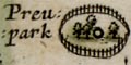
parks; ring of fence palings, perhaps with trees and
a great house.
|
|
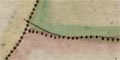
county boundary; dotted line, adjacent counties labelled
in Latin and English, eg: 'SURRIA Vulgo SURREY'.
|
|
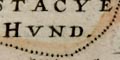
hundred boundaries; dotted line, hundreds are named in
upright block caps.
|
|
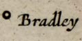
settlements; houses, hamlets, villages, cities, etc
|
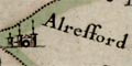
| market towns; and other towns
|
|
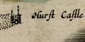
coastal defence, castles; circle and tower(s).
|
|
antiquities; 'tents', british tribes, hillforts.
|

|
miscellany; ships, religious house, windmills and watermills,
coppers.
|


