hills
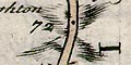
Bowen's Hampshire 1720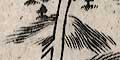

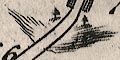
Bowen sometimes uses Ogilby's convention to distinguish ascents from descents, shewing descents with an upsidedown hillock.
Hills might be drawn beside or all round the road, denoting hilly ground?
|
| hillsBowen's Hampshire 1720 |
| Relief |
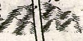
Hillocks are drawn to indicate ups and downs in the route.
The drawing of the hills is by shading lines (?), not always
very clearly done.
Bowen sometimes uses Ogilby's convention to distinguish ascents from descents, shewing descents with an upsidedown hillock. Hills might be drawn beside or all round the road, denoting hilly ground? |
 
| Bowen's Hampshire 1720, contents |

| feature list |
|
| General index |

| Old Hampshire Mapped |