roads
Bowen's Hampshire 1720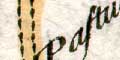


Most roads are drawn with two solid lines, some use dotted lines; this indicates fenced and unfenced roads. Across Farnham Common pl.129 mile 95-97 the engraving is dotted and full line together. Either a mistake in engraving has been corrected, or the status of the road has changed and this example of the map is printed from a later state of the plate.
The drafting tries to show the traveller what twists and turns might be expected. The road is probably compressed sideways to better fit the scrolls.
The Title of every Road is a Distinct Page; to each of
which is annex'd a Map of ye County wherin the Initial
or Boundary City Town or Place lies [for the nost-
part] or else Some part of the description of ye Road
itself.
The beginning of the Road is always at the bottom on
the left Hand, in the Page following the Title; whence you
proceed upwards from 1, 2, 3, 4, 5 &c Miles untill you come
to the Top of the first Collum; and so on in like man~er
from the Bottom of the 2d. 3d. &c. beginning in every
Page on the left Hand as before directed -
...
... And in your progress you meet
with Rills, Brooks, Rivers, Bridges, [the Plan of
the Road shewing whether built of Wood, Brick,
or Stone, No. of Arches contain'd in each if of any
Note] Woods, Trees, Mountains and Hills [shew-
ing their Ascent or Descent as they really are, ve-
ry Naturally] The Plan of the Road having at the
Same time the Ichnography of all Citys, Towns
&c. and the Compass in each Collum the True
Bearings both of the Road itSelf and of all the Towns
and Places that offer themselves to your View on either
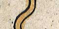
Side of it. The Road is all the Way bounded with 2 Paral-
lel Black Lines if inclosed or Hedg'd in on both sides, or
else if open, with 2 Parallel Dotted Lines, or lastly, if bound-
ed or Hedged in on One Side and open on the other, with
a Black Line and a Dotted Line Parallel to it.
The name of the Country the Road passes through is Engrav'd
on each Collum.
Distances along the road from London are marked by dots and a number at each mile. The map scale is about 2 1/4 miles to 1 inch.
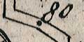
The Black Dots or Points in the middle of the Road,
are the Stations of the Miles, with their respective
nos. affixed to them.
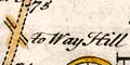
Side turnings are shown and diferentiated to show whether they go off sideways, or slightly ahead or back. Turnings are labelled with their destination eg
When any other Road Crosses or goes out of the RoadTwo or more turnings might be linked by a brace and labelled once, eg to Basing for two turnings pl.61 mile 46.
described there is an opening with the name of the
Place to which it goes:
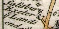
Where the junction is important (ie joins another road in the road book) it might have a more detailed information, eg just beyond Andover where a route splits, pl.78 mile 66+ to Salisbury Exeter & ye Lands end. Also at pl.129 mile 30 to Andover being the Road to Exeter and ye Lands End outside Bagshot, Surrey.
A dagger symbol is drawn by the road pl.264 mile 6.75. The label with this mark to Red Bridge belongs to the turning across the road. This convention is used more clearly at Brentford pl.60 mile 10 from London where there is both a mark by the turn and by the label the other side of the road.
A star tucked between road and a rill, pl.264 m 9 with the label to Ringwood makes sense if it belongs to the unlabelled turning in Christchurch about mile 10.
In both these instances Bowen is cramped for space to engrave the information.
The type of side road might be suggested, eg pl.217 mile 36 a way in a Lane
Very few side turnings are extended, but a single dotted line is used occasionally, eg pl.73 mile 66+ going to the church at Southwick.
A road might be named, eg pl.73 mile 40:- Rood Lane; this is unusual.
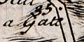
A gate in the road is marked pl.216 mile 35, south of Kingsclere a Gate.
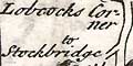
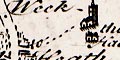
Very rarely a junction is named, eg Lobcocks Corner pl.62 mile 77, in Wiltshire.


