
| Old Hampshire Mapped
|
|
| Compass Roses
Notes
|
|
orientation
|
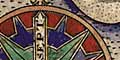
The orientation of a map is often shown by a compass rose;
this might be decorative or might be plain. It might show
just the north point, or might show many points of the
compass.
|
cardinal points
|
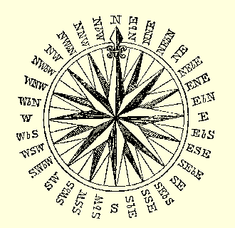
 The four main directions are the Cardinal points of the
compass; north, east, south, west.
The four main directions are the Cardinal points of the
compass; north, east, south, west.
These 4 directions are at right angles, 90 degrees to each
other, a 1/4 of the circle.
The cardinal points are also called 'principal points'.
|
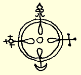
| north
| For many of us 'north' is the primary point of the
compass and 'up is north' on the map page; this is not true
for every situation or culture. Not all maps are printed
north upwards.
The point might be labelled N or North, or
perhaps in Latin, Septentriones, referring to the
seven stars that make up the constellation of The Bear,
or Plough, that is a pointer for the Pole Star in the North.
The Latin term might be abbreviated, eg Sept.
British maps traditionally mark the north point with a
fleur de lys.
|
| east
| The east point might be labelled E or East
or perhaps in Latin, Oriens, from the verb
orior, to rise, reminding us where the sun rises. The Latin
term might be abbreviated, eg Ori.
The point might be marked with a sort of cross potent or
cross patee.
|
| south
| The south point might be labelled S or South
or perhaps in Latin, Meridiens, referring to
where the sun is in the middle of the day [in the northern
hemisphere north of the tropics]. The Latin term might be
abbreviated, eg Meri.
The point might be marked with a crescent.
|
| west
| The west point might be labelled W or West
or perhaps in Latin, Occidens, from the Latin
occido, to fall or set, reminding us where the sun sets.
The Latin term might be abbreviated, eg Occi.
The point might be marked with a cross crosslet, usually
with a circle at the centre.
|
half cardinal
points
|
Between the cardinal points are the half cardinal
points of the compass; NE, SE, SW, NW.
These 4 points are at 45 degrees to the four cardinal
directions, an 1/8th of the circle.
The half cardinal points are also called 'quadrantal
points'.
|
|
false points
|
The directions dividing the cardinal and half cardinal points
are called false points; NNE, ENE, ESE, SSE, SSW,
WSW, WNW, NNW.
These 8 points are at 22.5 degrees to the others, an
1/16th of the circle.
The false points are also called 'intermediate points'
or 'three letter points'.
|
|
by points
|
Directions are further divided into the by points,
eg NbyE, SWbyS. (The rules for expressing these are best seen
from the diagram at the head of this page. You always go
from the nearest half cardinal or cardinal point 'by' ie
towards a cardinal point.)
The 16 by points are at 11.25 degrees to the others, a 1/32nd of
the circle. It would be unusual to find by points marked on the
compass rose of a land map; they are less unusual on
sea charts.
|
|
quarter points
|
The quarter points take the division two steps
further, eg Nby1/4E, SWby1/2S, Wby3/4N. (The half values
are called quarter points or half points.)
The quarter points are at 2.8125 degrees to the others, a
1/128th of the circle. It would be very unusual to find
quarter points marked on the compass rose of a map.
|
boxing the
compass
|
Reciting the 32 points of the compass in order is known
as 'boxing the compass'.
|
labelled
borders
|
Instead of having a compass rose the map might have its
borders labelled:- North, East, South,
and West, or perhaps the Latin equivalents:-
Septentriones, Oriens, Meridiones,
Occidens, which are explained above.
|
latitude
and
longitude
|
OR; the the map might have latitude and longitude scales
along its borders, and perhaps a latitude/longitude grid
overall, and not need a compass rose at all. As this grid
may not be rectangular a compass rose could confuse matters!
|
magnetic
deviation
|
The majority of the Hampshire maps studied are drawn
'N is up' ie have 'north' at the top of the page. Compass
north varies with time; if this is used to orientate the map
on paper, the orientation will vary. At a later period
the orientation of the map on the printed paper may be
arranged to suit a formal projection rather than have
compass north 'up'.
Matching the positions of a group of towns on an old map
to today's national grid positions shows that each map page
needs to be rotated to bring it 'into line'. The rotation needed
to transform page-north into a standard north on the
ngr projection, is listed below:-
     Saxton 1575    7.1 degrees E
     Norden 1595    8.2 degrees E
     Norden 1607    8.2 degrees E
     Speed 1611     7.4 degrees E
     Blaeu 1645     7.8 degrees E
     Jansson 1646   7.8 degrees E
     Blome 1673     8.5 degrees E
     Morden 1695    8.6 degrees E
     Kitchin 1751   3.5 degrees W
     Harrison 1788  3.4 degrees W
(The rotation may not be quite as exact as implied above.)
Keith gives a series of values for the magnetic variation
over the period 1550-1850:-
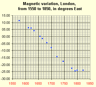
These values are for London, the variation in Hampshire is
not greatly different. John Norden declares he uses
compass north; the 8 degree rotation needed to bring his map
to today's standard is explained by the magnetic variation of
his time. Some later map makers may have copied an
outofdate compass north from an earlier map.
|
|
wind roses

|
These notes are mostly Lloyd Brown's ideas about wind roses.
Even though ancient astronomers developed the
mathematical expression of directions, early chart makers
gave directions on their charts by a more homely wind rose.
Heracleitus divided the heavens into four:-
|
| N c; | The Bear |
| E | Morning |
| S | The region opposite the Bear |
| W | Evening |
| N | |
|
|
The directions are general, not precisely N, E, S, W.
Poseidonius and Polybius, recounted by Strabo used four
more directions:-
|
| N c; | The darkness |
| NE | Summer sunrise |
| E | Equinoctial Sunrise |
| SE | Winter sunrise |
| S | The light |
| SW | Winter sunset |
| W | Equinoctial sunset |
| NW | Summer sunset |
| N | |
|
|
The direction of the equinoctial rising and setting vary
with your position on Earth, which Strabo pointed out.
Homer wrote of four winds, names:-
|
| N c; | Boreas |
| E | Eurus |
| S | Notus |
| W | Zephyrus |
| N | |
|
|
But the wind names were used in various ways. Strabo
observed that some writers refer to two principle winds,
Boreas and Notus, and others differing only slightly from these:-
|
| N c; | Boreas |
| NE | Eurus |
| E | |
| SE | Apeliotes |
| S | Notus |
| SW | Argestes |
| W | |
| NW | Zephyrus |
| N | |
|
|
And beside these confusions there were local names for winds
from particular places, Levante from the Levant, Greco
from Greece, ...
The Tower of Winds in Athens, built about 100BC, had eight
sides adorned with emblems, labelled:-
|
| N c; | Boreas |
| NE | Kaikias |
| E | Apeliotes |
| SE | Eurus |
| S | Notos |
| SW | Lips |
| W | Zephuros |
| NW | Skiron |
| N | |
|
|
Pliny, in his Natural History, reported two systems, four
winds and twelve winds, and that modern sailors have
simplified these into eight. He gave current and earlier
Greek terms (order not certain):-
|
| c; | modern
| greek
|
| N | Septentrio | Aparctias |
| NE | Aquilo | Boreas |
| E | Subsolanus | Apeliotes |
| SE | Vulturnus | Eurus |
| S | Auster | Notus |
| SW | Africus | Libs |
| W | Favonius | Zephyrus |
| NW | Corus | Argestes |
| N | |
|
|
The wind rose of twelve winds is found in writers down to
the 11th century, appearing again in the 14th century when
a sixteen wind system was also in use.
A system with intermediate winds named by compounds of the
four cardinal names was probably used by Flemish sailors,
from Bruges and elsewhere, from the time of Charlemagne.
In 1581, Michel Coignet gave a list of 8 winds, in Italian
and French:-
|
| N | Tramontana | Nort |
| NE | Griego | Nortest |
| E | Levante | Est |
| SE | Syrrocho | Sudest |
| S | Mezzodi | Sud |
| SW | Garbino | Sudoest |
| W | Ponente | Oest |
| NW | Maistro | Nortoest |
| N | |
|
|
contrasting the traditional style of names with the
compounding style.
A 17th century source gave an Accurate Table of Winds,
Ventorum Accurata Tabula, as a composite wind rose of
4, 8, 12, 24 and 32 directions; some of these points are:-
|
|
| N | Boreas | Aparctias | NORD | Tramontan
|
| NNE | | | Nord Nord est | Tramontana Graeco |
| NE | | Boreas | NORD EST | Graeco |
| ENE | | | est Nord est | Levante Graeco |
| E | Eurus | Apeliotes | EST | Levante |
| ESE | | | est Sud est | Levante Siroco |
| SE | | Euros | SUD EST | Siroco |
| SSE | | | Sud Sud est | Ostro Siroco |
| S | Notus | Notos | SUD | Ostro
OR Mezogiorno |
| SSW | | | Sud Sud ouest | Ostro Garbino |
| SW | | Lips | SUD OUEST | Garbino
OR Libegio |
| WSW | | | Ouest au Sudouest | Garbino ponante |
| W | Zephyrus | Zephyros | OUEST | Ponante |
| WNW | | | Oest Nord Ouest | Maestro Ponante |
| NW | | Argeotes | NORD OUEST | Maestro |
| NNW | | | Nord Nord Ouest | Maestro Tramontana |
| N | |
|
|
The quarter points were fairly clear in the compounding
style. eg 'Nord Quart au Nord est'. In the traditional style
the equivalent point is 'Quarta di Tramontana verso Graeco'
which is less immediately comprehensible.
Some of the 12 and 24 system directions in this compound
diagram are:-
|
| N | Septentrio | Sepentrio |
| | | Gallicus |
| | Aquilo | Supernas |
| | | Aquilo |
| | Caecias | Boreas |
| | | Carabas |
| E | Subsolanus | Solanus |
| | | Ornithiae |
| | Vulturnus | Cecias |
| | | Eurus |
| | Euronotus | Vulturnus |
| | | Euronotus |
| S | Auster | Auster |
| | | Altanus |
| | Libonotus | Libonotus |
| | | Africus |
| | Africus | Subuesper? |
| | | Argestes |
| W | Favonius | Favonius |
| | | Etesiae |
| | Corus | Circius |
| | | Caurus |
| | Thrascias | Corus |
| | | Thrascias |
| N |
|
|
(The greek is transliterated as well as I can; and I suspect
the author and engraver were each having trouble with
their sources too.)
The compounding style of direction names was adopted
by portuguese mariners before the 16th century. In the Arte
de Navegar by Pedro de Medina, 1545, the flemish names are
given in wind roses of four, eight, twelve (?16?) and
thirty-two points. The wind rose had evolved into the
compass rose that we know today.
This all makes me glad that we have the understandable
compounding system we have today; and inclined to understand
why mariners mostly, now, use headings in degrees although
steer SW is more immediate than steer 225 degrees
until you get used to it. The direction names tabulated
above demonstrate how dangerous is translation from old
terms into modern directions. But the tables may help you
read terms off an old map decorated with winds puffing airs
from the borders of a map, where you already have
their positions.
|
|
