
General Map
Kitchin's Hampshire 1767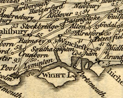
(item HMCMS:FA1999.138.0)
A General MAP of the / Direct & Principal Cross / ROADS, / in ENGLAND and WALES; / extended to Edinburgh in / SCOTLAND.from which this is the Hampshire portion. The map is an index map; the numbers against road segments refer to plates in the road book.
At the foot of the map is a rudimentary table of symbols, at least some explanation:-
Direct Roads are described thus //When using this index map do note that the page reference is to the start of the route, you may have to turn a page or two to find your place.
Cross Roads thus /
The figures on the Roads in this Map refer to the Pages where they may be found.
The map has no scale line. Measuring a few place-to-place distances on the map it is possible to get an estimate of its scale, about:-
1 to 3500000
55 miles to 1 inch


