roads
Kitchin's Hampshire 1767
to BasingA junction might be labelled, eg:-
to Winchester
Lobcocks Corner
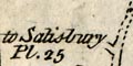
to Salisbury Pl.25There is another example at Basingstoke where the road to Alton is labelled, to be followed on pl.91. Although the important route to Stockbridge from here, Basingstoke, is labelled, its plate number is not given.
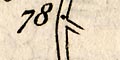
You have to be careful following these references, the first plate of the sequence is usually given, and you have to turn on to find the bit you want.
There are useful hints in the footer printed below the map, eg (also on plate 25):-
Another Way from London to Salisbury is from Basingstoke to Stockbridge in Pl.58 & from thence to the Hutt in this Plate at 77m. The several Roads from Salisbury are shown in Plates 55, 84, 93 & 95.
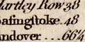
The ROAD from LONDON to the Lands End,
in CORNWALL.
Containing from the Royal Exchange to
...
Bagshot ....... 29
Hartley Row ... 38
Basingstoke ... 48
Andover ....... 66 1/4
Salisbury ..... 83 3/4
...


