 |
settlements
Kitchin's Hampshire 1767 |
|
| settlements |
Settlements in the strip maps of Kitchin's Post Chaise Companion
are drawn with blocks or groups of blocks, perhaps laid out in
streets in larger towns.
The notes below come from a quick look through the plates; the
maps are not interesting enough to deserve a detailed study at
this phase of the Old Hampshire Maps project.
|
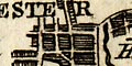 |
city: A city most likely has a street plan; and is labelled
in block caps, (eg: pl.41 m.28):-
WINCHESTER
|
|
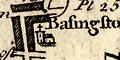
town: Larger towns have groups of blocks along the road
making a street plan, perhaps with a church as well;
labelled in lowercase upright text, (eg: pl.91 m.43):-
Basingstoke
Southampton has streets and gardens (burgess plots?) behind
its houses.
|
|
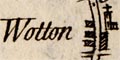
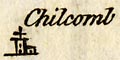
village: Villages on the road have fewer blocks along the
road, not making street plans (eg: pl.25 m.51); villages off the
road may be shown by a drawing of a church alone (eg: pl.41 m.27);
labelled in lowercase italic text, eg:-
Wooton
Chilcomb
The church symbols are drawn 'horizontally' not correctly
aligned EW; some churches have a flat top tower with a cross,
others have a steeple - but I have no idea whether this is by
chance or design. Two of Winchesters churches are drawn and
labelled:-
H[ii]e Church
Little St. Bartholm
|
|
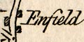
hamlet: Hamlets may be shown by a few blocks on the road
without a church (eg: pl.50 m.75); labelled, if at all in lowercase italic text:-
Enfield
|
|
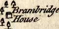
house: A house might be drawn as a picture; labelled in lowercase italic text (eg: pl.55 m.70):-
Brambridge House
|


