
Old Hampshire Mapped
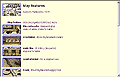
Map Features
Old Hampshire Mapped
- [MKR]FTR.htm in the maker's directory, eg:- saxton1/SAX1FTR.htm
A consistent set of features is considered for each map; a particular map is unlikely to depict all the different sorts of features. Features show up in file names as three letter codes:-
TIT = title cartoucheOther features may be coded in an adhoc way.
CMP = compass rose or whatever
SCL = scale line etc
LLS = lat and long scales etc
DEC = decoration (ships, sea monsters, ...)
MST = sea monster etc
SHP = ship, galleon, etc
LET = swash lettering etc
ARM = coats of arms
INS = transcription and spelling, ie of inscriptions
COA = coast line
RIV = rivers
HIL = relief, hills, ...
BEC = beacons
TRE = woods, forests, trees
PRK = parks
BRG = bridges
BDY = county boundary
HUN = hundreds
SYM = symbols
HAM = hamlets
VIL = villages
MKT = market and other towns
CIT = cities
ROD = roads
FRT = fortifications
REL = monastical, religious, ...
HSE = houses
CST = castle, coastal defence
ANT = antiquities
MIL = mills
COP = copperas
BGH = boroughs
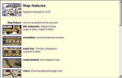
<html>
<head>
<title>[Maker]'s Hampshire [map date]</title>
</head>
<body bgcolor="#FFFFDD"><a name="top"></a>

<table>
<tr>
<td valign="top" align="right">
<a href="[MAKER].htm" target="_top"><img src="[MKR]TITL.gif"></a></td>
<td valign="top">
<h2>Map features</h2>
[Maker]'s Hampshire [map date]</td>
</tr>

<tr><td colspan="2"><hr></td></tr>

<tr>
<td valign="top" align="right">
<b>Map feature</b></td>
<td valign="top">
click on a symbol to find out more<br></td>
</tr>

<tr>
<td align="right" valign="top">
<a href="[MKR][FTR].htm"><img src="[MKR][FTR]1.jpg"></a></td>
<td valign="top">
<b>[feature term]</b>; [brief note]</td>
</tr>

<tr>
<td align="right" valign="top">
<img src="[MKR][FTR]1.jpg"></td>
<td valign="top">
<b>[feature term]</b>; [less brief note]</td>
</tr>

</table>

<hr>

<table>
<tr>
<td align="right" valign="top">
<a href="[MAKER].htm" target="_top">
<img src="[MKR]TITL.gif"></a><br>
<img src="../left120.gif"></td>
<td valign="top">
[Maker]'s Hampshire [map date], contents</td>
</tr>
<tr>
<td align="right" valign="top">
<a href="../HANTSMAP.htm" target="_top">
<img src="../HANTBTN.gif"></a></td>
<td valign="top">
Old Hampshire Mapped</td>
</tr>
</table>

<hr>
Map [Institution code:Identity number]

<hr>

[copyright statement]

</body>
</html>
