| Map features
Morden's playing card map, Hampshire 1676
|
|
|
|
Some images can be clicked for more information.
|
|
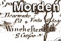
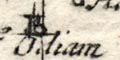
title; abbreviated, in a box at the top of the playing
card.
|
|
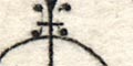
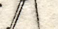
compass rose; a plain circle, lines for the four
cardinal directions.
|
|
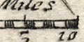
scale line; below a pair of compasses, scale line of 10
miles.
|
|
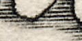
coast shaded; with horizontal lines with are carried into harbours and river mouths. Portsea Island and Hayling Island are
(too) clearly marked.
|
|
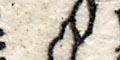
rivers; major rivers are shown by a solid wiggly line.
|
|
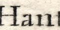
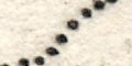
county; the county boundary is a dotted line. The
contiguous counties are labelled, eg:-
Pt. of Wilt
etc. This labelling did not appear on the very first edition of
the playing cards.
|
|
settlements; villages, towns, cities.
|
|
roads; are what makes this map exciting: this is the first
road map of Hampshire.
|
|
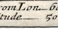
statistics; a box at the bottom of the playing card has
data about the county:�
Length. ________________________ 66.
Bredth. ________________________ 30.
Circumference. ________________ 176.
Southamp~: { D. from Lon. _ 60. 78.
{ Latitude. ____ 50. 56.
|


