| Hillforts, Roman place names
Norden's Hampshire 1607
|
|

| click for feature map
|
| Earthworks
|
On Norden's map old trenches and forts, ie earthworks are shown
by a modern style tumulus symbol, a hatched circle, with a flag.
The sites noticed are listed below:-
|
|
| hillforts |
BEWARE: to get back to this list after clicking on an item,
use the back button.
'modern' name (parish; ngr) = old name (hundred) if given
|
 |
Balksbury (Andover parish; SU351446)
|
|
|
Beacon Hill Camp (Burghclere parish; SU458572)
Note in Camden's Britannia
|
|
|
Bury Hill hillfort (Upper Clatford parish; SU346435)
|
|
|
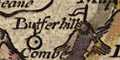
Butser Hill hillfort (Langrish parish; SU712203)
= Butserhill (East Meane Hundred)
|
|
|
Danebury Ring (Nether Wallop parish; SU324377)
= Dunbury hill (Andover extra Hundred)
also marked as a deserted place
|
|
|
Hengistbury Head hillfort (Bournemouth parish; SZ170908)
|
|
|
Malwood Castle (Minstead parish; SU277121)
|
|
|
Merdon Castle (Hursley parish; SU421265)
|
|
|
St Catherine's Hill hillfort (Winchester parish; SU484276)
|
|
|
Woolbury Ring (Little Somborne parish; SU381353)
|
|
roman
place names
| Several roman place names are given
on Norden' map, with no special symbol. They are generally attached
to modern places.
|
|
|
Avon mouth (Christchurch parish)
= Alauni Fl: Ostium
Note in Camden's Britannia
|
|
|
Bitterne (Southampton parish)
= Clausentum (Waltham Hundred)
Note in Camden's Britannia
|
|
|
Brige
= Brage (Thornegate Hundred)
|
|
|
Portsmouth Harbour (Portsmouth parish; SZ69)
= Portus Magnus (Portesdowne Hundred)
Note in Camden's Britannia
|
|
|
Ringwood (Ringwood parish; SU149054)
= Regnum
Note in Camden's Britannia
|
|
|
Silchester (Silchester parish; SU6261)
= Silchester, Vindonum (Holdshott Hundred)
This is mistaken labelling; Vindonis is more likely Neatham,
Alton; the error is copied from map to map at this period.
Silchester is Calleva.
Notes in Camden's Britannia:-
Silchester /
Vindonum /
crop marks /
Onions pennies
|
|
|
Winchester (Winchester parish; SU478293)
= Venta
Roman cantonal capital, earlier a belgic town - Venta Belgarum
Note in Camden's Britannia
|
Camden
Britannia
|
Norden's map of Hampshire was published in
Camden's 'Britannia'
along with a description of the county which includes a nice
observation about crop marks at Silchester, this in 1607:-
... This is found by continuall observation (as I have learned of
the inhabitants of this place) that although the ground bee fertile
and fruitfull inough, yet in certaine places crossing one another,
the corne doth not thrive so well, but commeth up much thinner then
else where, by which they suppose the streets of the citie went in
old time. There are heere daily digged up, bricks such as we
call Britaine-bricks, and great store of Romane coine which they
terme Onions pennies. For, they dreame that this Onion was a Giant,
and dwelt in this citie. There are digged up also many
times inscriptions ...
|


