| compass rose, scale line
Norden's Hampshire 1607
|
|
Compass rose
Scale
| 
|
|
|
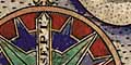
On Norden's map the compass rose and scale line are combined,
together with an inscription of the map maker's and engraver's
names
|
Cardinal
points
|
The cardinal (N, E, S, W), half cardinal (NE, SE, SW, NW) and
false points (NNE, ENE, ESE, SSE, SSW, WSW, WNW, NNW) of the
compass are indicated, north is marked with a fleur de lys, and
the cardinal points are named:-
|
| SEPT
|
Septentriones: refering to the seven stars that make
up the constellation of The Bear, or Plough, that is a pointer
for the Pole Star in the North |
| ORI
|
Oriens: from the Latin orior, to rise, where the sun
rises in the East
|
| MERI
|
Meridiens: middle of the day, where the sun is then
in the South
|
| OCCI
|
Occidens: from the Latin occido, to fall or set,
where the sun sets in the West
|
|
| Notes about compass roses.
|
| Scale Line
|
The scale of 10 miles is divided only into half miles. The
map scale, from this scale line, is about 1 to 243000 wrongly
assuming a statute mile which had not been institutionalised
by that time, ie:-
1 to 240000
4 miles to 1 inch
A better estimate of scale can be made from town positions,
comparing known town-town distances, using DISTAB.exe. the map
scale is about:-
1 to 380000
6 miles to 1 inch
The map maker's mile is an old english mile = 1.24 statute miles.
|
|
| Notes about scales.
|


