John Norden

 |
John Norden was born about the 1540s. He graduated from Hart
Hall, Oxford and began a career as a lawyer which involved him in
land tenure and surveying for country gentry. In the 1590s he had
the idea of a Speculum Britanniae or Mirror of
Britain, conceived as a series of pocket guide books to the
counties of Britain. These would combine new maps of the counties
with the sort of historical descriptions made by William Camden
in Britannia. John Norden, backed by Lord Burghley, began
his surveying in 1591. He had the favour of government; with
financial assistance from William Waad, a clerk to the Privy Council
and client of Lord Burghley. In 1594 a warrant was issued for him:-
[... to travail through England and Wales to make perfect
descriptions chartes and mappes of the same by information,
inquisition, and view ...]
The Privy Council instructed:-
[Lieutenants of Counties, Mayors, Sheriffs, Justices of the Peace and
all others of Her Majesties officers and loving subjects ... to
permit and suffer the said J. Norden quietly, and without any manner
of let or hindrance, to travel and pass from place to place ...]
and to help him with access to record books etc. Norden comments
about his guides; I, Norden:-
[... a straunger guided by the direction of such, as by discretion
of men in Aucthoritie are thought fit to yeelde me direct
information ... who yet thorogh their simplicitie or partialitie,
may miscarry the most provident observer ... and what I observe is
from them, if the thing be hidden (as some time it is) from mine
own view ...]
When Lord Burghley died, 1598, the project seems to have
collapsed. Various parts of the completed work were published, and
a volume of manuscript material presented to Elizabeth I in an
attempt to get funding, but without success. Norden eventually gave
up the project; concentrating on land surveying and writing: he was
a successful surveyor and author of religious texts.
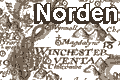
The Hampshire map drawn for Speculum Britanniae still exists
in manuscript in the collection of the British Museum. An engraving
was made from this, perhaps in the 1590s but is only known from
later states published by Stent and by Overton. The map described
in these notes was engraved about 1607, presumably from the
drawing of 1595. This slightly simplified and smaller version,
engraved by William Hole, was published in Camden's 'Britannia',
1607. The map includes hundred boundaries, the hundreds listed,
and consistent symbols for settlements explained by a key.
Norden was a prolific land surveyor and author; producing
handbooks for surveyors and guidebooks for travellers. he
invented the triangular distance table, printed for the first time
in 'England: An Intended Guyde for English Travailers', 1625. He
advocated the detail mapping of town centres:-
... the most principall townes cyties and castles within
evrry Shire shoulde be breefly and expartly plotted
out, in estate and forme as at this day they were ...'
|
|
References
|
Box, E G: 1935=1937: Norden's Map of Hampshire, 1595: Hampshire
Field Club: XIII: pp165-169
Box, E G: 1932=1935: Hampshire in Early Maps and early
Roadbooks: Hampshire Field Club: XII: pp221-235
Eden, P (ed):: Dictionary of Land Surveyors and Local Cartographers
of Great Britain and Ireland, 1550-1850
Hodgkiss, A G: 1981 (4th edn): Discovering Antique maps:
Shire Publications (Princes Risborough, Buckinghamshire)::
ISBN 0 85263 581 8; an inexpensive and approachable introduction
to old maps
Kitchen, Frank: 1991: John Norden's Speculum Britanniae ...:
ProcHFC: 47: pp.181-89
Kitchen, Frank: 1997: John Norden, c1547-1625, Estate Surveyor,
County Mapmaker and Devotional Writer: Imago Mundi: vol.49:
pp.43-61
Lawrence, Heather: 1982: Permission to Survey: Map Collector:
no.19: pp.16-20
Norden, John: 1595: Chorograpical Description of the Severall
Shires::: BM AddMSSS 31.853
Penfold, Alastair J: 1994: Introduction to the printed Maps
of Hampshire: Hampshire CC Museums Service
|