scale line
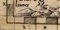
Norden's Hampshire 1595The scale of miles goeth rounde about the MappAll four map borders are chequered to show miles, west-east and north-south; the origin of the scales is top left. Each two miles is labelled across top and bottom, 2, 4, 6, ... 48. The labelling on the sides runs down a, b, c, ... x (no 'i' or 'u'). Besides being scale lines the scales and the grid printed across the map in fine lines make an index grid. John Norden's provision of an index grid is an innovation in map making.
The scale can be estimated from the scale line wrongly assuming it is a scale of modern statute miles. A better figure for the scale has been estimated from the positions of towns. This also provides a value of the 'old english mile' used in John Norden's scale line. The process is described in notes DISTTAB.rul accompanying software which does the sums. The map scale is about 1 to 241379, say:-
1 to 240000John Norden used an:-
4 miles to 1 inch
old english mile = 1.24 statute miles


