| Bridges
Ogilby's Hampshire 1675
|
|
|
Bridges are less certain to interpret from Ogilby's maps,
except where clearly drawn as a hump backed bridge.
Ogilby:-
6. Bridges are usually noted with a Circular Line like an Arch,
but are generally, imply'd where the River or Brooks crost are
not drawn through the Road.
Example pl.97(6) at mile 11.
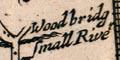
Ogilby sometimes notes that bridges are stone and sometimes wood,
eg pl.51(1) at mile 33.
|
|
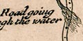
A ford might be drawn quite clearly, eg pl.51(3) at mile 58.
There is probably a bridge if the river is not drawn across the
road like this.
|
|
| bridges |
BEWARE: to get back to this list after clicking on an item,
use the back button.
'modern' name (parish; ngr) = old name (plate (scroll) mile) |
 |
bridge (Andover parish; SU364453)
= (pl.32(1) m.66)
| |
|
|
bridge (Copythorne parish; SU32811730)
= Ouxbridge (pl.97(2) m.82)
|
|
|
bridge (Rushmoor parish; SU871576?)
= (pl.51(1) m.33)
|
|
|
ferry (Southampton parish; SU4311)
= Ferry, the (pl.51(5) m.78)
|
|
|
ferry (Southampton parish; SU4311)
= Ferry, the (pl.51(6) m.0)
|
|
|
ferry (Southampton parish; SU4311)
= Ferry, the (pl.97(7) m.0)
|
|
|
Ashley Bridge (New Milton parish; SZ26569387)
= (pl.97(6) m.18)
|
|
|
Black Bridge (Winchester parish; SU486288)
= (pl.97(1) m.67)
| |
|
|
Black Bridge (Winchester parish; SU486288)
= (pl.97(7) m.12)
| |
|
|
Black Bridge (Winchester parish; SU486288)
= (pl.39(6) m.28)
| |
|
|
Chewton Bridge (Christchurch parish; SZ223938)
= Somerford bridge (pl.97(6) m.25)
|
|
|
City Bridge (Winchester parish; SU486293)
= (pl.97(1) m.67)
| |
|
|
City Bridge (Winchester parish; SU486293)
= (pl.97(7) m.12)
| |
|
|
City Bridge (Winchester parish; SU486293)
= (pl.39(6) m.28)
| |
|
|
Efford Bridge (Hordle parish; SZ305941)
= (pl.97(6) m.20)
|
|
|
Hartford Bridge (Hartley Wintney parish; SU774578)
= Hartfordbridg (pl.25(4) m.38)
|
|
|
High Bridge (Otterbourne parish; SU467214)
= High bridge (pl.51(4) m.71)
|
|
|
Hyde Street Bridge (Winchester parish; SU481298)
= (pl.97(1) m.67)
| |
|
|
Hyde Street Bridge (Winchester parish; SU481298)
= (pl.97(7) m.12)
| |
|
|
Hyde Street Bridge (Winchester parish; SU481298)
= (pl.39(6) m.29)
| |
|
|
Iford Bridge (Bournemouth parish; SZ1393)
= (pl.97(6) m.9)
| |
|
|
Knight's Bridge (Ashford Hill with Headley parish; SU507634)
= Great Knight. bridg (pl.81(3) m.30)
|
|
|
Knight's Bridge (Ashford Hill with Headley parish; SU507634)
= Litle Knight bridge (pl.81(3) m.30)
|
|
|
Middle Bridge (Romsey parish; SU350207)
= (pl.97(2) m.79)
|
|
|
Middle Bridge (Romsey parish; SU350207)
= (pl.51(6) m.9)
|
|
|
Ower Bridge (Copythorne parish; SU32661676)
= (pl.97(2) m.82)
|
|
|
Ports Bridge (Portsmouth parish; SU654045)
= Portsey bridg (pl.30(6) m.69)
|
|
|
Seward's Bridge (New Alresford parish; SU574322)
= (pl.51(3) m.61)
|
|
|
Seward's Bridge (New Alresford parish; SU574322)
= Sewers bridge (pl.97(1) m.61)
|
|
|
Sheet Bridge (Petersfield parish; SU765242)
= Sheet bridg (pl.30(5) m.54)
|
|
|
Sheet Bridge (Petersfield parish; SU765242)
= Sheetbridg (pl.39(5) m.9)
|
|
|
Soke Bridge (New Alresford parish; SU588329)
= (pl.51(3) m.60)
|
|
|
St Leonards Bridge (Ferndown Town parish; SU097019)
= Palmers bridge (pl.97(4) m.101)
|
|
|
Stanbridge (Petersfield parish; SU755218)
= Stanbridge (pl.81(6) m.67)
|
|
|
Stoning Bridge (Ringwood parish; SU143052)
= (pl.97(3) m.97)
| |
|
|
Town Bridge (Christchurch parish; SZ16189275)
= Redford bridge (pl.97(6) m.11)
|
|
|
Waterloo Bridge (Christchurch parish; SZ16289285)
= (pl.97(6) m.21)
| |
|
|
Woolson Bridge (Hook parish; SU73735482)
= Halsum bridg (pl.25(4) m.41)
|


