| Hills on the route
Ogilby's Hampshire 1675
|
|
relief
hillocks
|
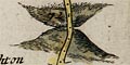
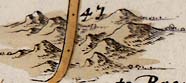 Inclines up and down are indicated by hillocks; a range of hills
beside the road might be drawn, eg pl.25(5) at mile 47.
Inclines up and down are indicated by hillocks; a range of hills
beside the road might be drawn, eg pl.25(5) at mile 47.
|
|
|
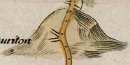 An ascent, Ogilby says:-
8. Ascents are noted as the Hills in ordinary Maps, ...
Example pl.30(5) at mile 59.
|
|
|
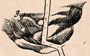 A descent, Ogilby:-
... Descents e contra, with their Bases upwards.
Example pl.97(3) at mile 89
|
|
| hills |
BEWARE: to get back to this list after clicking on an item,
use the back button.
'modern' name (parish; ngr) = old name (plate(scroll) mile) |
 |
Abbotts Ann Down (Abbotts Ann parish; SU3140)
= (pl.26(1) m.70)
|
|
|
Andover Down (Longparish parish; SU3945)
= (pl.25(6) m.63)
|
|
|
Butser Hill (Langrish parish; SU7120)
= (pl.30(5) m.58)
|
|
|
Cottington's Hill (Kingsclere parish; SU5256)
= (pl.81(3) m.35)
|
|
|
Dun Hill (Steep parish; SU7324)
= Dunhill (pl.81(5) m.65)
|
|
|
Fryern Hill (Eastleigh parish; SU4420)
= (pl.97(7) m.7)
|
|
|
Gravel Hill (Buriton parish; SU7118)
= (pl.30(5) m.59)
|
|
|
Isle of Wight (Nether Wallop parish; SU2437)
= (pl.26(1) m.75)
|
|
|
Meon Hill (Longstock parish; SU3435)
= (pl.53(2) m.72)
|
|
|
Mogshade Hill (Minstead parish; SU2409)
= (pl.97(3) m.90)
|
|
|
Pauncefoot Hill (Romsey Extra parish; SU341200?)
= (pl.51(6) m.9)
|
|
|
Pauncefoot Hill (Romsey Extra parish; SU341200?)
= (pl.97(2) m.80)
|
|
|
Plantation Hill (Kingsclere parish; SU5457)
= Pettum hill (pl.81(3) m.35)
|
|
|
Portsdown (Portsmouth parish; SU6_0_)
= Portsey down (pl.30(6) m.68)
|
|
|
Quarley Hill (Quarley parish; SU2642)
= (pl.32(1) m.73)
|
|
|
Rooks Down (Sherborne St John parish; SU6053)
= Rooks down (pl.81(4) m.40)
|
|
|
Rotten Hill (Laverstoke parish; SU5048)
= (pl.25(6) m.57)
|
|
|
St Giles Hill (Winchester parish; SU4929)
= (pl.97(1) m.67)
|
|
|
Star Hill (Hartley Wintney parish; SU7758)
= (pl.25(4) m.38)
|
|
|
Suddern Hill (Over Wallop parish; SU2637)
= (pl.26(1) m.74)
|
|
|
Wool Down (Laverstoke parish; SU4948)
= (pl.25(6) m.57)
|


