| miscellaneous
Ogilby's Hampshire 1675
|
|
| Miscellany
|
All sorts of interesting items are shown by the road, and
note:-
9. Whatever is posited upon or within the Scroll, is presum'd
to bear the same Scale as the Road it self.
This can help decide just what feature is being described when
checking on today's maps.
|
|
windmill - example pl.30(6) at mile 67, post mill on
Portesdown,
|
|
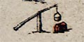
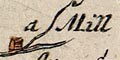
water mill - example pl 32(1) at mile 69, 'a Mill'
and perhaps an example from outside Hampshire which shows the
water wheel, pl.83(7) at mile 81.
|
|
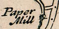
paper mill - example pl.51(2) at mile 43, on the River Wey
near Alton
|
|
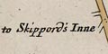
inn - very few inns are marked; they are presumably taken for
granted at any village.
The turning pl.25(5) at mile 52 is labelled:- 'to Skippord's Inne'
|
|
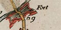
fort - a polygonal artillery fort is clearly shown at
Cosham, pl.30(6) at mile 69.
|
|
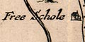
school - example pl.51(2) at mile 49 'Free Schole', this
is Eggar's School, Alton, founded 1641.
|
|
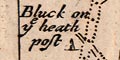
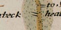
post - we don't (as yet) know the significance of the post
at pl.51(6) at mile 10 'Bluck on the heath post'
|
|
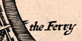
ferry - example pl.97(7) at mile 0, 'the Ferry'.
|
|
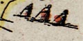
tumulus - three tumuli, barrows, are drawn at pl.53(1) at
mile 58.
|
|
gate - a town gate might be drawn, eg pl.30(6) at mile 73
at Portsmouth
|
|
|
sweep well - wells are not generally shown, presumably
taken for granted or not relevant to a traveller crossing rivers.
But two sweep wells have been labelled on Ogilby's maps,
one of them in Dorset at pl.53(4) at mile 93 near Tidpit, which is
now in Hampshire.
This device appears to be a shaduf.
An ancient well is labelled Woodgate Wells at pl.81(4)
mile 38.
|
|
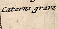
grave - at pl.81(4) at mile 42 Caterns grave.
|
|
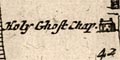
chapel - example pl.81(4) at mile 42 'Holy Ghost Chap.'
|
|
cross - example, drawn beside the road at pl.97(3) at
mile 93 which is near where Picket Post is now
|
|
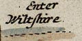
county - boundaries are clearly marked by a dotted line
across the route, with text stating what county is being entered
- as the traveller rides away from London:-
Enter Wiltshire
Another route intot that county has:-
Enter Witshire at ye Ash tree
|
|
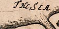
sea - the sea is treated in diffent ways on different maps.
It may be drawn with coast form lines on one, and coast shading
on another.
|
|
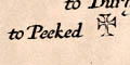
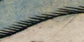
heath - shown by pecked engraving beside the road.
Ogilby provides a running commentary on the vegetation beside
his routes. This is probably not very formally done, but
is generally helpful and informative. Other fields:-
Corn fieles on both sides
Arrable
Pasture on both sides
Sheepp Downes
Inclosures on both sides
|
|
| Out of Hampshire
|
|
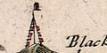
beacon - there is no beacon shown in Hampshire, but on
one of the plates in this study there is one in neighbouring
Wiltshire, on Beacon Hill pl.39(2) at mile 46. The beacon is
drawn with a fire basket on a post with a ladder.
|
|
|
and
- bowling green - example pl.30(1) at mile 8
Bouling green
- iron mills - example pl.30(2) at mile 22
- priory - example pl.30(3) at mile 30
- henge - example pl.32(2) at mile 83 Stonehenge
- quarry - example pl.32(5) at mile 125
- causeway - example pl.32(6) at mile 234 across the
Somerset levels
- brick kilns - example pl.39(1) at mile 39
- marl pit - example pl.39(3) at mile 59 a marle pit
These features can be found on the sheets studied, though they are
out of Hampshire.
|


