
Old Hampshire Mapped
Scale Lines
Notes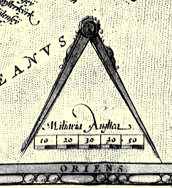
Many maps use a scale line to indicate the scale of the map. This is particularly useful in the present age of easy photocopying when the map might be unknowingly enlarged or reduced in the process; the scale line is changed equally and remains a true indicator of the map's scale. The more we work with maps and plans the more it seems best (just good manners) to always provide a scale line. Simply quoting a numerical scale is not good enough.
It is useful to express the scale of a map as a numerical ratio. Thus the familiar scale of:-
1 inch to 1 milecan be numerically expressed as
1 to 63360It is pretty quick, with a pocket calculator, to measure a scale line on an old map and work out the map's scale. An example:-
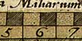
scale line 10 miles = 67.3 mm longIt seems easier to measure accurately in millimetres, mm, than fractions of an inch. The scale is got thus:-
calculate 10 x 63360 x 25.4 / 67.3Remember:- 63360 inches in 1 mile; 25.4mm in 1 inch.
= 239139.87
BUT: the old english mile was not the present day statute mile, so this calculation fails for old maps. For example Saxton's mile has been shown to be about 1.25 statute miles.
Remember too that your measurement of 67.3 mm is not precise, it is probably no better than plus minus 0.2 mm, an error of plus minus 0.3% in the example. This error must be reflected in the way you express the scale. You must round off some. For the example above the scale can be given no more accurately than:-
1 to 239000
BUT: the calculation assumes that the miles on the scale line of the map are modern statute miles. On early maps this is an unreasonable assumption: BEWARE.
... a myle to conteyne eight furlongs and every furlong to conteyne fortie luggs or poles and ev'ry lugg or pole to conteyne sixteen foot and half ...The mile comes out at the familiar 1760 yards, each of 3 feet of 12 inches; 1 mile is 5280 feet, 63360 inches.
Before this time a variety of customary miles were in use, and they remained in use for a long while after. The Elizabethan statute mile gradually came into more common use, but was only well established by an Act of 1824, 5 Geoge IV cap 74.
Early maps often carried more than one scale line, for 'great', 'middle' and 'small' miles or whatever, reflecting the uncertain nature of the customary distance represented.
'mile' derives from the Latin milliarius thousand or miliarium milestone; standing for a distance of mille passum a thousand paces. A pace was 5 feet (but, just how long was the foot?)
DISTAB.exeto do this job.
A handy list of map scales and place-to-place distances is available if you want to do calculations by hand.

