
Old Hampshire Mapped

Scales
Norden 1595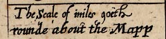
On John Norden's map of 1595, printed at the foot of the table of hundreds it says:-
The scale of miles goeth rounde about the Mapp
All four map borders are chequered to show miles, west-east and north-south; the origin of the scales is top left. Each two miles is labelled across top and bottom, 2, 4, 6, ... 48. The labelling on the sides runs down a, b, c, ... x (no 'i' or 'u'). Besides being scale lines the scales and the grid printed across the map in fine lines make an index grid.
The map maker's mile is an old english mile = 1.24 statute miles