| Jenner's Map
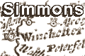
Simmons's Hampshire 1635-43
|
|
| map features
|
Some images can be clicked for more information.
|
|
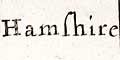
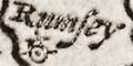
title: there is no title on the tiny map; the title
of the table of distances is:-
Hamshire
|
|
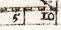
scale line: The maps has a scale line of 10 miles.
|
|
coast shaded: the coast line is shaded.
Southampton Water, and Portsmouth and Langstone Harbours
are clearly shown; Hamble and Titchfield Havens are
exaggerated.
|
|
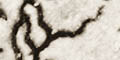
rivers: rivers are drawn as wiggly lines.
|
|
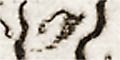
hillocks: a couple of hillocks are drawn to
indicate relief ... just to show willing!
beacons: So few hills are drawn that it is tempting
to think that the three shown in the south of the county
have some special significance. It is just possible that two
of them represent Bushy or Sarisbury Beacon and Hythe
Beacon. Norden's maps 1595 and 1607 include good coverage
of beacons.
|
|
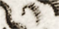
settlements: are marked by a dot and circle with
a tower.
|


