
Old Hampshire Mapped
Relief
Notes- important or isolated hills
- steep scarp
- uneven ground, hilliness
- high ground, ie altitude
- watersheds
- survey points
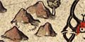
The drawing of hills has to compete with the placing other information on the limited map space. We do not directly know what priority was given to hills; it would be interesting to know in what order symbols were engraved on the printing plate. Hills are a prominent feature of the map's appearance; they vary in size.
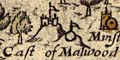
The first category of hill, an important or isolated hill, might be the site of a fort, beacon, castle, or town. There might be a name, eg Cast of Malwood.
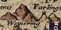
A steep scarp might be shown as a line of hills, for example at Portsdown by Portsmouth, Stoner Hill northwest of Petersfield, or Watership Down in the north of the county. Some scarps are missed, for example the edge of the hills by Ashmansworth.
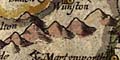
The line of hills drawn north of Winchester is not a scarp, but is high rolling downland, and is a watershed.
The other categories of hills seem to have a lower priority, and it is less clear what was intended. There seem to be more hillocks drawn where ground is high, say above 100m. In Hampshire high ground tends to be hilly ground, which is not true in all places. Low lying hilly ground seems to lack hillock symbols; but the space on the map is often taken up by trees in woods and forests.
A fascinating suggestion has been made that the hills shown might be those which were climbed by the map maker or an assistant and used as a survey point. (Manley, G: 1938: Saxton's Survey of Northern England: Geog J: vol.83: pp.308-316)
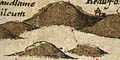
On Norden's map of Hampshire there is at least one group of hills, west of Ringwood, that is less justified; they might just be decoration. The hills fill a space on the map but in reality are not as dramatic as the drawing.

