| | |
 Carrel Crown Bridge
 |
 |
Wootton Rivers, Wiltshire KAC39.28 |
|

|
KandAC mile 39
|
|
|
|
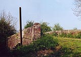
These accommodation bridges look pretty much out of use in many cases.
This one is not completely abandoned. The weight restriction sign has
gone from its pole, which is a length of bullhead rail.
|
|
|
The bridge is a brick built accommodation bridge, 39 miles 28 chains
from Reading, it connects fields to north and south of the canal.
|
|
|
headroom |
10ft6ins |
|
|
depth of water |
5ft8ins |
|
|
|
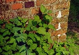
Stinging nettles, Urtica dioica, and brickwork - english bond.
|
|
|
|
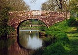
Carrel Crown Bridge from the westward. The railway is visible under
the arch.
|
|
|
|
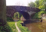
Carrel Crown Bridge from the east side.
|
|
|
The 'accepted' spelling of the bridge's name is taken from Hammond's
map, 1975; the other spelling from GEOprojects's map, 1997. I have no
idea which is correct. The spellings are a good illustration of a
cartographic error that is common as map makers, or property owners,
copy names from earlier source material.
|
|

|
Kennet and Avon Scrapbook 2000
|
|