 Kennet and Avon Canal Kennet and Avon Canal |
 |
|
|
|
MILE 36
|
Grafton and Burbage, Wiltshire : KAC36.00=KAC37.00 |
|

|
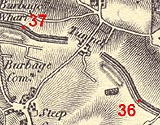
KandAC mile 36
|
|
|
|
KandAC mile 36 - OS 1inch map, early 19th century
|
|
|
... the canal burrows through the summit, the railway climbs up over;
and, wow! comes down on the other side ...
|
|
|
The Kennet and Avon Canal from mile 36 to 37 is at its summit level,
it passes through the Bruce Tunnel at the watershed from the Thames,
Kennet, Dun etc basin to the Vale of Pewsey. The London to the south
west railway line is on the north of the canal crossing to the south
as the canal goes through the tunnel. The towpath is on the south
side.
|
|
|
|
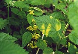
Yellow archangel, Lamiastrum galeobdolon, by the towpath.
|
|
|
A narrow copse of magnificent beech trees lines the south side of the
canal.
|
|
|
Parish boundary Burbage - Savernake: SU21946346
|
|
|
Staying level as it must the canal runs into a deep cutting as the
railway, out of sight on the north rises over the hill.
|
|
|
|
Approaching the Bruce Tunnel in a cutting; the beech grove is on the
towpath side.
|
|
|
|
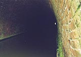
Bruce Tunnel, Burbage
|
|
|
|
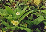
Primroses, Primula vulgaris, by the towpath.
|
|
|
|
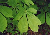
Horse chestnut leaves, Aesculus hippocastanum.
|
|
|
|
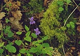
Violets, Viola rivinianum?, by the towpath.
|
|
|
The canal creeps along out of its cutting; slightly gloomy. The
railway is out of sight on the south side.
|
|

|
Kennet and Avon Scrapbook 2000
|
|