|
ACM1934.14:-
|
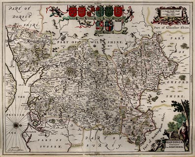
Map, hand coloured copper plate engraving, Hantoniae Comitatus cum Bercheria,
ie Hampshire and Berkshire, scale about 4 miles to 1 inch, from the Atlas Novus,
by Jan Jansson, Amsterdam, Netherlands, 1646.
|
|
The Old English Mile used by the map maker is 1.23 statute miles.
|
|
map feature:-
|
hand coloured & title cartouche & compass rose & up is W & coat
of arms & scale lines (2, english and german miles) & coast shaded &
rivers & county & hundreds & woods & forests & trees &
relief & hillocks & parks & beacons & settlements & labelled
borders |
|
scale line:-
|
6 miles = 47.5 mm |
|
inscription:- |
printed -on- title cartouche
HANTONIAE / COMITATUS / Cum BERCHERIA
|
|
inscription:- |
printed -on- borders
Occidens / Septentrio / Oriens / Meridies
|
|
dimension:- |
wxh, sheet = 58x48cm |
|
wxh, plate = 553x443mm (approx) |
|
wxh, map = 552x440mm |
|
scale = 1 to 250000 ? (from town positions using DISTAB.exe) |
 |
|

|
Map Group -- Jansson 1646 -- with Research Notes
|
 |
|
|
town names:-
|
|
Hantoniae
|
Hampshire
|
|
map name
|
modern name
|
|
Alton
|
Alton
|
|
Andover
|
Andover
|
|
Basingstoke
|
Basingstoke
|
|
Bushwaltham
|
Bishops Waltham
|
|
Christ Church
|
Christchurch
|
|
Farham
|
Fareham
|
|
Fording bridge
|
Fordingbridge
|
|
Gosport
|
Gosport
|
|
Havant
|
Havant
|
|
Kingscler
|
Kingsclere
|
|
Lymington
|
Lymington
|
|
Alresford
|
Alresford
|
|
Odiam
|
Odiham
|
|
Petersfeild
|
Petersfield
|
|
Portesmouth
|
Portsmouth
|
|
Ringwood
|
Ringwood
|
|
Rumsey
|
Romsey
|
|
Southampton
|
Southampton
|
|
Stockbridg
|
Stockbridge
|
|
Whitchurch
|
Whitchurch
|
|
Winchester
|
Winchester
|
|
 |
|

| top of page |
| MN: 4.10.2001 |


