|
ACM1934.74.2:-
|
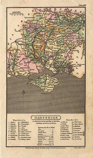
Map, hand coloured engraving, Hampshire, and the Isle of Wight, scale about
15 miles to 1 inch, drawn and engraved by H Cooper, published by R Phillips,
Bridge Street, Blackfriars, London, 1808.
|
|
Plate XIV from A Topographical Dictionary of the United Kingdom by Benjamin
Pitts Capper.
|
|
map feature:-
|
hand coloured & north point (fleur de lys) & scale line & sea shaded
& coast shaded & rivers & county & hundreds & table of
hundreds (keyed by numbers) & settlements & roads & canals |
|
inscription:- |
printed -on-
HAMPSHIRE
|
|
inscription:- |
printed -on- bottom centre
Published Jany. 1, 1808, by R. Phillips, Bridge Street, Blackfriars, London.
/ Cooper delt. et sculp.
|
|
scale line:-
|
10 miles = 17.1 mm |
|
dimension:- |
wxh, sheet = 12.5x21.5cm |
|
wxh, map (excluding table at foot) = 102x134mm |
|
scale = 1 to 940000 ? (1 to 941137 from scale line assuming modern mile) |
 |
|

|
Map Group -- Cooper 1808 -- with Research Notes
|
 |
|
|
town names:-
|
|
Hampshire
|
Hampshire
|
|
map name
|
modern name
|
|
Alton
|
Alton
|
|
Andover
|
Andover
|
|
Basingstoke
|
Basingstoke
|
|
Bishops Waltham
|
Bishops Waltham
|
|
Christ Church
|
Christchurch
|
|
Fareham
|
Fareham
|
|
Fordingbridge
|
Fordingbridge
|
|
Gosport
|
Gosport
|
|
Havant
|
Havant
|
|
Kingsclere
|
Kingsclere
|
|
Lymington
|
Lymington
|
|
New Alresford
|
Alresford
|
|
Odiham
|
Odiham
|
|
Petersfield
|
Petersfield
|
|
Portsmouth
|
Portsmouth
|
|
Ringwood
|
Ringwood
|
|
Romsey
|
Romsey
|
|
Southampton
|
Southampton
|
|
Stockbridge
|
Stockbridge
|
|
Whitchurch
|
Whitchurch
|
|
Winchester
|
Winchester
|
|
 |
|

| top of page |
| MN: 4.10.2001 |


