|
ACM1934.74.7:-
|
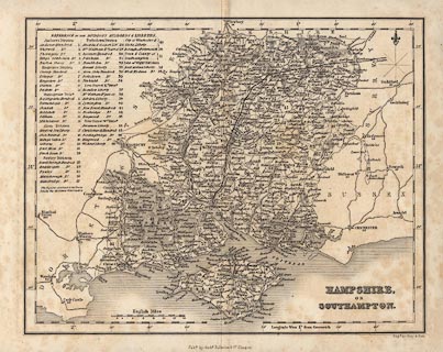
Map, uncoloured engraving, Hampshire or Southampton, and Isle of Wight, scale
about 8 miles to 1 inch, perhaps by James Bell, 1834, engraved by Gray and Son,
published in a General Atlas by Archibald Fullarton and Co, Glasgow,
Strathclyde, 1839.
|
|
map feature:-
|
not coloured & north point (lines for cardinal and half cardinal directions,
fleur de lys for north) & scale line (14 miles, chequered) & lat and
long scales & sea shaded & coast shaded & rivers & relief &
hill hachuring & parks & county & divisions & hundreds &
table of hundreds & settlements & roads & railways (just one line
from London to Southampton) & canals |
|
inscription:- |
-on- bottom right
HAMPSHIRE, / OR /SOUTHAMPTON.
|
|
inscription:- |
printed -on- bottom
Pubd. by Archd. Fullarton & Co. Glasgow. / Engd. by Gray & Son.
|
|
scale line:-
|
14 miles = 43.6 mm |
|
dimension:- |
scale = 1 to 520000 ? (1 to 516762 from scale line assuming modern mile) |
|
longitude, Winchester = 1d 8.8m W (approx) |
 |
|
|
reference:- |
Fullarton: 1839 (c): General Atlas |

|
Map Group -- Bell 1834 -- with Research Notes
|
 |
|
|
town names:-
|
|
Southampton
|
Hampshire
|
|
map name
|
modern name
|
|
Alton
|
Alton
|
|
Andover
|
Andover
|
|
Basingstoke
|
Basingstoke
|
|
Bishops Waltham
|
Bishops Waltham
|
|
Christ Church
|
Christchurch
|
|
Fareham
|
Fareham
|
|
Fordingbridge
|
Fordingbridge
|
|
Gosport
|
Gosport
|
|
Havant
|
Havant
|
|
Kingsclere
|
Kingsclere
|
|
Lymington
|
Lymington
|
|
New Alresford
|
Alresford
|
|
Odiham
|
Odiham
|
|
Petersfield
|
Petersfield
|
|
Portsmouth
|
Portsmouth
|
|
Ringwood
|
Ringwood
|
|
Romsey
|
Romsey
|
|
Southampton
|
Southampton
|
|
Stockbridge
|
Stockbridge
|
|
Whitchurch
|
Whitchurch
|
|
Winchester
|
Winchester
|
|
 |
|

| top of page |
| MN: 4.10.2001 |


