|
FA1988.26:-
|
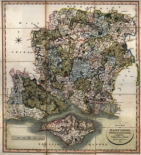
Map, hand coloured copper plate engraving, A New Map of Hampshire, with Isle
of Wight, scale about 2.5 miles to 1 inch, by John Cary, 86 St James's Street,
London, 1809, edition published 1825.
|
|
The map shows the Portsmouth Canal which was opened 1822 and closed 1827.
|
|
inscription:- |
-on-
A / NEW MAP / OF / HAMPSHIRE, / DIVIDED INTO HUNDREDS. / EXHIBITING / Its
Roads, Rivers, Parks &c. / By JOHN CARY, Engraver. / 1825.
|
|
inscription:- |
-on-
London: Published by J. Cary Engraver & Map-seller; No.86, St. James's
Street, Jany. 1st. 1825.
|
|
map feature:-
|
hand coloured & mounted & sectioned for folding (3x5 pieces) & title
cartouche (oval) & compass rose & scale line & lat and long scales
& coast shaded & rivers & relief & hill hachuring & forests
& woods & trees & parks & county & hundreds &
settlements & roads & canals |
|
scale line:-
|
10 miles = 92.4 mm |
|
dimension:- |
wxh = 51.5x58.8cm |
|
scale = 1 to 170000 ? (1 to 174171 from scale line assuming modern mile) |
|
longitude, Winchester = 1d 16.7m W (approx) |
 |
|

|
Map Group -- Cary 1809b -- with Research Notes
|
 |
|
|
town names:-
|
|
Hampshire
|
Hampshire
|
|
map name
|
modern name
|
|
Alton
|
Alton
|
|
Andover
|
Andover
|
|
Basingstoke
|
Basingstoke
|
|
Bishops Waltham
|
Bishops Waltham
|
|
Christ Church
|
Christchurch
|
|
Fareham
|
Fareham
|
|
Fordingbridge
|
Fordingbridge
|
|
Gosport
|
Gosport
|
|
Havant
|
Havant
|
|
Kingsclere
|
Kingsclere
|
|
Lymington
|
Lymington
|
|
New Alresford
|
Alresford
|
|
Odiham
|
Odiham
|
|
Petersfield
|
Petersfield
|
|
Portsmouth
|
Portsmouth
|
|
Ringwood
|
Ringwood
|
|
Romsey
|
Romsey
|
|
Southampton
|
Southampton
|
|
Stockbridge
|
Stockbridge
|
|
Whitchurch
|
Whitchurch
|
|
Winchester
|
Winchester
|
|
 |
|

| top of page |
| MN: 4.10.2001 |


