|
FA1991.13.1:-
|
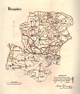
Map, hand coloured lithograph, Hampshire, showing the parliamentary
divisions, scale about 6.5 miles to 1 inch, made for the Reform Bill 1832, by
Lieut Robert K Dawson RE, map maker, 1831, copied, 1937.
|
|
Derived from the Ordnance Survey, lithographed by R Martin, London; shows
division of the county, principal places of county election, boroughs returning
2 members and 1 member.
|
|
Copied in the Report of the Municipal Corporation Boundaries Commission, 1937.
|
|
map feature:-
|
hand coloured & county & hundreds & roads & settlements &
scale line & compass rose & table of symbols & electoral data |
|
inscription:- |
printed -on- upper left
Hampshire
|
|
inscription:- |
printed -on- lower left
R. Martin, Lithog. 124, High Holborn & 51, Carey St.
|
|
inscription:- |
printed -on- lower right
Robert K. Dawson / Lieut. R.E.
-- signature |
|
scale line:-
|
6 miles = 47.4 mm |
|
dimension:- |
wxh, sheet = 28.5x35cm |
|
scale = 1 to 410000 ? (from town positions using DISTTAB.exe) |
 |
|

|
Map Group -- Dawson 1832 -- with Research Notes
|
 |
|
|
town names:-
|
|
Hampshire
|
Hampshire
|
|
map name
|
modern name
|
|
Alton
|
Alton
|
|
Andover
|
Andover
|
|
Basingstoke
|
Basingstoke
|
|
Bishops Waltham
|
Bishops Waltham
|
|
Christchurch
|
Christchurch
|
|
Fareham
|
Fareham
|
|
Fordingbridge
|
Fordingbridge
|
|
Havant
|
Havant
|
|
Kingsclere
|
Kingsclere
|
|
Lymington
|
Lymington
|
|
New Alresford
|
Alresford
|
|
Odiham
|
Odiham
|
|
Petersfield
|
Petersfield
|
|
Portsmouth
|
Portsmouth
|
|
Ringwood
|
Ringwood
|
|
Romsey
|
Romsey
|
|
Southampton
|
Southampton
|
|
Stockbridge
|
Stockbridge
|
|
Whitchurch
|
Whitchurch
|
|
Winchester
|
Winchester
|
|
 |
|

| top of page |
| MN: 4.10.2001 |


