|
FA1991.14:-
|
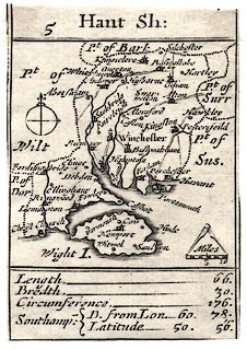
Map, uncoloured engraving, Hant Sh, ie Hampshire, with the Isle of Wight,
scale about 27.5 miles to 1 inch, originally the playing card map by Robert
Morden, 1676, published as an atlas sheet about 1785.
|
|
Very small, showing only principal towns and routes; this is the earliest road
map of Hampshire.
|
|
The sheet map is probably from the original plates slightly amended in an atlas,
A Brief Description of England and Wales, published by H Turpin, 104 St John's
Street, West Smithfield, London, about 1785.
|
|
inscription:- |
-on-
Hant Sh:
|
|
map feature:-
|
not coloured & compasses & compass rose & scale line &
settlements & roads & coast shaded & county & rivers |
|
inscription:- |
-on-
Length. - 66. / Bredth. - 30. / Circumference. - 176. / Southamp: D. from
Lon. - 60. 78. / Latitude 50. 56.
|
|
scale line:-
|
10 miles = 10.3 mm |
|
dimension:- |
wxh, sheet (trimmed) = 6x8.5cm |
|
wxh, map (excluding cartouches) = 56x58mm |
|
scale = 1 to 1800000 ? (from town positions using DISTAB.exe) |
 |
|
|
reference:- |
: 1785 (?): Brief Description of England and Wales: Turpin, H (London) |

|
Map Group -- Morden 1676 -- with Research Notes
|
 |
|
|
town names:-
|
|
Hant Sh.
|
Hampshire
|
|
map name
|
modern name
|
|
Alton
|
Alton
|
|
Andover
|
Andover
|
|
Basingstoke
|
Basingstoke
|
|
Bushwaltham
|
Bishops Waltham
|
|
Christ Church
|
Christchurch
|
|
Farham
|
Fareham
|
|
Fordingbridg
|
Fordingbridge
|
|
Havant
|
Havant
|
|
Kingsclere
|
Kingsclere
|
|
Lemington
|
Lymington
|
|
Alersford
|
Alresford
|
|
Odiam
|
Odiham
|
|
Petersfeild
|
Petersfield
|
|
Portsmouth
|
Portsmouth
|
|
Ringwood
|
Ringwood
|
|
Rumsey
|
Romsey
|
|
S Hampton
|
Southampton
|
|
Stokbridg
|
Stockbridge
|
|
Whitchurch
|
Whitchurch
|
|
Winchester
|
Winchester
|
|
 |
|

| top of page |
| MN: 4.10.2001 |


