|
KD1992.289:-
|
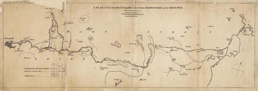
Map, uncoloured engraving, Plan of the intended Navigable Canal from
Basingstoke to the River Wey, scale roughly 1 mile to 1 inch, made for the canal
prospectus, engraved by William Faden, Charing Cross, London, surveyed by Joseph
Parker, about 1777.
|
|
General route of proposed canal and collateral cuts shown.
|
|
map feature:-
|
not coloured & north point & scale line & rivers & relief &
hill hachuring & parks & settlements & streets & canals &
table of distances |
|
inscription:- |
-on-
A PLAN of the intended Navigable Canal from BASINGSTOKE to the RIVER WEY. /
Engraved by Wm. Faden, Charing Cross. / ... / Surveyed by Joseph Parker.
|
|
scale line:-
|
3 miles = 65.1 mm |
|
dimension:- |
wxh, sheet = 82x29.5cm |
|
wxh, plate = 804x283mm (approx) |
|
wxh, map = 790x267mm |
|
scale = 1 to 74000 ? (1 to 74163 from scale line assuming modern mile) |
 |
|

|
Map Group -- Parker 1777 -- with Research Notes
|
 |
|
|
town names:-
|
|
Hamp Shire
|
Hampshire
|
|
map name
|
modern name
|
|
Basingstoke
|
Basingstoke
|
|
 |
|

| top of page |
| MN: 4.10.2001 |


