|
KD1996.1:-
|
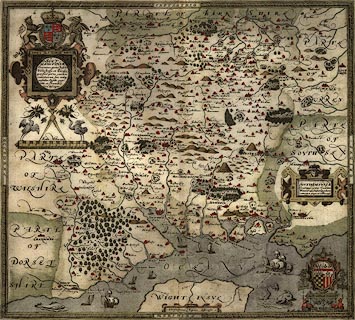
Map, hand coloured copper plate engraving, Southamtoniae, ie Hampshire, scale
about 4 miles to 1 inch, engraved by Leonard Terwoort, Antwerp, Netherlands,
published by Christopher Saxton, map maker, London? about 1575.
|
|
The Old English Mile used by the map maker is 1.25 statute miles.
|
|
Published in the Atlas of England and Wales; it was usually issued in hand
coloured form; measurements and notes made in the field were worked up later,
with the help of earlier manuscript maps if available; Saxton almost certainly
used the rudimentary triangulation techniques first described by the
cartographer Frisius, Belgium, 1533.
|
|
Hills are drawn in profile to provide a general impression of the local
topography, while named settlements are shown by a variety of symbols including
a church with tower; rivers, coastline, some bridges, deer parks and woods are
all included; the most obvious omission on Saxton's maps, to our eyes, are
roads, which were not included on general county maps until the 1690s.
|
|
The map '... provides us with our first english example of accurate
cartography': Colonel Close: 1930:: Hampshire Field Club.
|
|
Saxton's county maps were engraved by Ryther, Hogenberg, Reynolds, Terwoort and
Scatter.
|
|
map feature:-
|
scale line & coat of arms (royal and family) & parks & settlements
& ships & sea monsters & title cartouche & hand coloured |
|
inscription:- |
-on-
Christophorus Saxton descripsit
|
|
inscription:- |
-on-
SOVT / HAMTONIAE / Comitus (preter Insulas / Vectis Jersey, et Garnsey /
quoe sunt partes eiusdem / comitatus) cum suis undiq / confinibus Oppidis,
pagis, / villis, et fluminibus, / vera descriptio
|
|
inscription:- |
printed -on-
LEONADUS TERWOORT ANTVERPIANUS SCULPSIT
|
|
scale line:-
|
10 miles = 83.2 mm |
|
dimension:- |
wxh = 49.8x43.2cm |
|
scale = 1 to 240000 ? (from town positions using DISTAB.exe) |
 |
|
|
reference:- |
Saxton, Christopher: 1579: Atlas of England and Wales (map taken from) |

|
Map Group -- Saxton 1575 -- with Research Notes
|
 |
|
|
town names:-
|
|
Southamtoniae
|
Hampshire
|
|
map name
|
modern name
|
|
Aulton
|
Alton
|
|
Andover
|
Andover
|
|
Basingstoke
|
Basingstoke
|
|
Bisshopswaltham
|
Bishops Waltham
|
|
Christ Churche
|
Christchurch
|
|
Faram
|
Fareham
|
|
Gosport
|
Gosport
|
|
Havant
|
Havant
|
|
Kingesclere
|
Kingsclere
|
|
Lemyngton
|
Lymington
|
|
Alresford
|
Alresford
|
|
Odiam
|
Odiham
|
|
Petersfelde
|
Petersfield
|
|
Portesmouth
|
Portsmouth
|
|
Ringwood
|
Ringwood
|
|
Rumsey
|
Romsey
|
|
Southamton
|
Southampton
|
|
Stockbridge
|
Stockbridge
|
|
Whitchurche
|
Whitchurch
|
|
Winchester
|
Winchester
|
|
 |
|

| top of page |
| MN: 4.10.2001 |


