|
KD1996.3:-
|
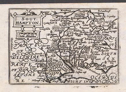
Map, uncoloured engraving, Southampton, ie Hampshire, scale about 16.5
statute miles to 1 inch, by Pieter van den Keere, 1605 and 1620, published
1666.
|
|
The map is from the 1666 edition of the atlas, with the text for Surrey on the
reverse, but is the same map as the 1620 edition.
|
|
The Old English Mile used by the map maker is 1.25 statute miles.
|
|
map feature:-
|
not coloured & title cartouche (strapwork?) & scale line (chequered, 10
miles) & swash lettering & coast shaded & rivers & trees &
forests & woods & county & settlements (symbols graded in size
etc) |
|
scale line:-
|
10 miles = 18.9 mm |
|
inscription:- |
printed -on- title cartouche
SOUT / HAMPTON.
|
|
dimension:- |
wxh, map = 122x84mm |
|
wxh, plate = 125x87mm (?) |
|
wxh, sheet = 16x10.5cm |
|
scale = 1 to 1100000 ? (from town positions) |
 |
|

|
Map Group -- Keer 1605 -- with Research Notes
|
 |
|
|
town names:-
|
|
Southampton
|
Hampshire
|
|
map name
|
modern name
|
|
Aulton
|
Alton
|
|
Andoner
|
Andover
|
|
Basingstoke
|
Basingstoke
|
|
Bishops waltham
|
Bishops Waltham
|
|
Christ churche
|
Christchurch
|
|
Faram
|
Fareham
|
|
Havant
|
Havant
|
|
Kingesclere
|
Kingsclere
|
|
Lernyngton
|
Lymington
|
|
Alresford
|
Alresford
|
|
Odiam
|
Odiham
|
|
Petersfelde
|
Petersfield
|
|
Portesmouth
|
Portsmouth
|
|
Rengwood
|
Ringwood
|
|
Rumsey
|
Romsey
|
|
Southhamton
|
Southampton
|
|
Stockbridge
|
Stockbridge
|
|
Winchester
|
Winchester
|
|
 |
|

| top of page |
| MN: 4.10.2001 |


