|
KD1996.7:-
|
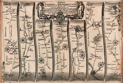
Strip map, uncoloured engraving, road map of part of The Road from London to
Southampton, Hampshire, from the road book, Britannia, published by John Ogilby,
White Friars, London, 1675.
|
|
Pl.51 from near Bagshot? Surrey, through Aldershot, Hampshire, through Farnham,
Surrey, through Alton, New Alresford, Twyford, to Southampton, Hampshire; from
Southampton to Romsey, Hampshire, and into Wiltshire, to Salisbury.
|
|
map feature:-
|
not coloured & title cartouche & not coloured & compass rose &
road distances & roads & settlements & rivers & coast shaded
& trees & relief & hillocks & county & parks &
streets |
|
inscription:- |
printed -on- title cartouche
The Road from. / LONDON to SOUTHAMPTON. / By JOHN OGILBY Esqr. His Maties.
Cosmographer / ....
-- cherubs |
|
dimension:- |
wxh, sheet = 48x39.5cm |
|
wxh, map = 467x313mm |
|
scale = 1 to 63360 ? (nominal) |
 |
|
|
reference:- |
Ogilby, John: 1675: Britannia; A Geographical and Historical Description of the
Principal Roads thereof |

|
Map Group -- Ogilby 1675 -- with Research Notes
|
 |
|
|
town names:-
|
|
Hampshire
|
Hampshire
|
|
map name
|
modern name
|
|
Alton
|
Alton
|
|
Aleresford
|
Alresford
|
|
Rumsey
|
Romsey
|
|
Southampton
|
Southampton
|
|
 |
|

| top of page |
| MN: 4.10.2001 |


