|
KD1996.16:-
|
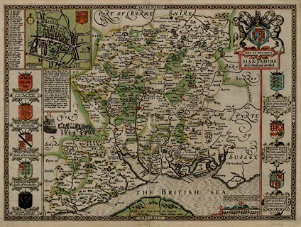
Map, hand coloured copper plate engraving, Hantshire described and divided,
Hampshire with part of the Isle of Wight, scale about 4 miles to 1 inch, and a
town plan of Winchester, by John Speed, engraved by Jodocus Hondius, about
1611.
|
|
The Old English Mile used by the map maker is 1.22 statute miles.
|
|
Published in the Theatre of the Empire of Great Britain, 1611.
|
|
map feature:-
|
hand coloured & picture frame border & title cartouche & strapwork
cartouche & swash lettering & compass rose & scale line & coat
of arms & sea moire effect & coast shaded & rivers & relief
& hillocks & forests & trees & parks & county & hundreds
& settlements & streets |
|
scale line:-
|
8 miles = 65.3 mm |
|
inscription:- |
printed -on- title cartouche, upper right
HANTSHIRE / described and devided.
|
|
inscription:- |
printed -on- lower centre
Iodocus Hondius caelavit
|
|
inscription:- |
printed -on- bottom right
Performed by Iohn Speede and are to be solde in Popes / head alley by I.
Sudbury and G. Humbell Cum Privelegio.
|
|
dimension:- |
wxh, sheet = 53x41cm |
|
wxh, plate = 516x382mm |
|
wxh, map = 511x378mm |
|
scale = 1 to 240000 ? (from town positions using DISTAB.exe) |
 |
|
|
reference:- |
Speed, John: 1611 (and later edns): Theatre of the Empire of Great Britain
(taken from) |

|
Map Group -- Speed 1611 -- with Research Notes
|
 |
|
|
town names:-
|
|
Hantshire
|
Hampshire
|
|
map name
|
modern name
|
|
Alton
|
Alton
|
|
Andover
|
Andover
|
|
Basingstoke
|
Basingstoke
|
|
Bushwaltham
|
Bishops Waltham
|
|
Christ Church
|
Christchurch
|
|
Farham
|
Fareham
|
|
Fording bridge
|
Fordingbridge
|
|
Gosporte
|
Gosport
|
|
Havant
|
Havant
|
|
Kingscler
|
Kingsclere
|
|
Lymington
|
Lymington
|
|
Alresford
|
Alresford
|
|
Odiam
|
Odiham
|
|
Petersfeild
|
Petersfield
|
|
Portesmouth
|
Portsmouth
|
|
Ringwood
|
Ringwood
|
|
Rumsey
|
Romsey
|
|
Southampton
|
Southampton
|
|
Stokbridg
|
Stockbridge
|
|
Whitchurch
|
Whitchurch
|
|
Winchester
|
Winchester
|
|
 |
|

| top of page |
| MN: 4.10.2001 |


