|
KD1996.17:-
|
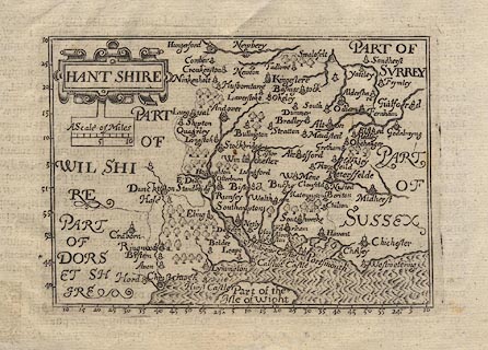
Map, uncoloured engraving, Hant Shire, ie Hampshire, scale about 16.5 miles
to 1 inch, by John Bill, published in an abridged edition of Britannia, by
William Camden, about 1626.
|
|
The Old English Mile used by the map maker is about 1.31 statute miles.
|
|
map feature:-
|
not coloured & lat and long scales & scale line & title cartouche
(strapwork) & swash lettering & sea moire effect & coast shaded
& county & rivers & woods & forests & trees &
settlements (graded by symbols) |
|
scale line:-
|
10 miles = 19.4 mm |
|
inscription:- |
printed -on- title cartouche
HANT SHIRE
|
|
dimension:- |
wxh, sheet = 19x15cm |
|
wxh, plate = 126x92mm |
|
wxh, map = 119x86mm |
|
scale = 1 to 1100000 ? (from town positions using DISTAB.exe) |
|
longitude, Winchester = 23d 9.5m E (approx) |
 |
|
|
reference:- |
Camden, William: 1626 (abridged edn): Britannia |

|
Map Group -- Bill 1626 -- with Research Notes
|
 |
|
|
town names:-
|
|
Hant Shire
|
Hampshire
|
|
map name
|
modern name
|
|
Alton
|
Alton
|
|
Andover
|
Andover
|
|
Basingstock
|
Basingstoke
|
|
Bushe / Waltham
|
Bishops Waltham
|
|
Christ Church
|
Christchurch
|
|
Farham
|
Fareham
|
|
Havant
|
Havant
|
|
Kingeslere
|
Kingsclere
|
|
Lymington
|
Lymington
|
|
Alresford
|
Alresford
|
|
Odiam
|
Odiham
|
|
Petersfelde
|
Petersfield
|
|
Portsmouth
|
Portsmouth
|
|
Ringwood
|
Ringwood
|
|
Rumsey
|
Romsey
|
|
Southampton
|
Southampton
|
|
Stockbridge
|
Stockbridge
|
|
Winchester
|
Winchester
|
|
 |
|

| top of page |
| MN: 4.10.2001 |


