|
KD1996.23:-
|
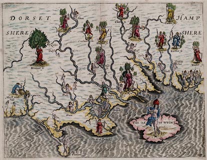
Map, hand coloured copper plate engraving, fantastical map of Dorset,
Hampshire and the Isle of Wight, published in Poly-Olbion, by Michael Drayton,
poet, engraved by William Hole, about 1612.
|
|
Showing the rivers of Hampshire and Dorset, decorated with goddesses and
allegorical figures for forests, islands, etc.
|
|
This bizarre map was published for inclusion in 'Poly-Olbion, or Chorographical
Description of all the Tracts, Rivers, Mountains, Forests and other parts of the
Renowned Isle of Great Britain, by Michael Drayton, poet; it is of no
topographical interest; but it is an interesting document of its time,
containing numerous classic allusions reminiscent of contemporary poetry and
masques.
|
|
map feature:-
|
hand coloured & sea moire effect & coast shaded & rivers &
forests |
|
dimension:- |
wxh, sheet = 33.5x28cm |
|
wxh, image = 328x251mm |
|
wxh, plate = 33x25.5cm (approx) |
 |
|
|
reference:- |
Drayton, Michael: 1612 & 1622; Poly-Olbion |

|
Map Group -- Drayton 1612 -- with Research Notes
|
 |
|
|
town names:-
|
|
Hampshere
|
Hampshire
|
|
map name
|
modern name
|
|
|
|
|
 |
|

| top of page |
| MN: 4.10.2001 |


