|
FA1991.9:-
|
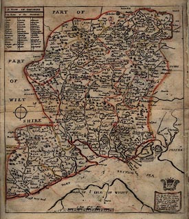
Map, hand coloured etching, A Mapp of Hantshire, ie Hampshire with the Isle
of Wight, scale about 4 miles to 1 inch, by Richard Blome, about 1673.
|
|
Bloome's maps, published in his Britannia of 1673, were based on Speed's maps of
1611.
|
|
The plates were etched, some of them by Wencelaus Hollar, instead of the more
usual copper plate engraving.
|
|
Bloome was an entrepreneur, skilled in attracting sponsors for his publications;
he even used interchangeable coats of arms for different editions of his maps;
this map is dedicated to Charles, Lord St John.
|
|
map feature:-
|
dedication & table of hundreds & county & hundreds & scale line
& compass rose & title cartouche & hand coloured &
settlements |
|
scale line:-
|
10 miles = 65.1 mm |
|
inscription:- |
-on-
A MAPP OF HANTSEERE
|
|
inscription:- |
-on- bottom right
To the Rt. Honl. Charles / Ld. St. Ion, Son & Heire / To the Rt. Honl. Iohn
Ld. / Marquis of Winchester. / Ld. Lieutenant of / the County of Hanshire / This
Mapp is humbly / Dedicated by Ric: Blome.
-- cartouche, with crest above |
|
dimension:- |
wxh = 28x34.5cm |
 |
|
|
reference:- |
Bloome, Richard: 1673: Britannia (taken from) |

|
Map Group -- Blome 1673 -- with Research Notes
|
 |
|
|
town names:-
|
|
Hantshire
|
Hampshire
|
|
map name
|
modern name
|
|
Alton
|
Alton
|
|
Andover
|
Andover
|
|
Basingstoke
|
Basingstoke
|
|
Waltham
|
Bishops Waltham
|
|
Christ church
|
Christchurch
|
|
Fareham
|
Fareham
|
|
Fordingbridge
|
Fordingbridge
|
|
Gosporte
|
Gosport
|
|
Havant
|
Havant
|
|
Kingscler
|
Kingsclere
|
|
Lymingto~
|
Lymington
|
|
Alesford
|
Alresford
|
|
Odiam
|
Odiham
|
|
Petersfeild
|
Petersfield
|
|
Portesmouth
|
Portsmouth
|
|
Ringwood
|
Ringwood
|
|
Rumsey
|
Romsey
|
|
Southampto~
|
Southampton
|
|
Stokbridg
|
Stockbridge
|
|
Whitchurch
|
Whitchurch
|
|
Winchester
|
Winchester
|
|
 |
|

| top of page |
| MN: 4.10.2001 |


