|
FA1996.33:-
|
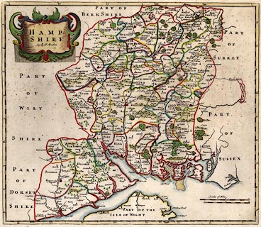
Map, hand coloured engraving, Hamp Shire, ie Hampshire, scale about 5 miles
to 1 inch, by Robert Morden, published in an edition of Britannia by William
Camden, 1695.
|
|
The Old English Miles used by the map maker is 1.23 statute miles.
|
|
This is the second Hampshire county map with roads indicated practically; the
few routes are a selection of those published by John Ogilby, 1675.
|
|
map feature:-
|
hand coloured & title cartouche & scale line (two) & county &
hundreds & settlements & rivers & trees & woods & forests
& relief & hillocks & coast shaded & roads (few) & lat and
long scales & time from Greenwich |
|
scale line:-
|
10 miles = 74.3 mm |
|
scale line:-
|
10 miles = 81.4 mm |
|
inscription:- |
printed -on- map
HAMP / SHIRE / by Robt Morden.
|
|
dimension:- |
wxh, sheet = 45x39cm |
|
wxh, plate = 424x367mm |
|
wxh, map = 419x364mm |
|
scale = 1 to 240000 ? (calculated from sample of towns, approx) |
|
scale = 1 to 300000 ? (from town positions using DISTAB.exe) |
|
longitude, Winchester = 1d 17.5m W (very rough) |
 |
|
|
reference:- |
Camden: 1695: Britannia |
|
Norgate, Martin; Norgate, Jean: 1997: Notes from Morden's Map of Hampshire:
Hampshire CC Museums Service:: ISBN 1 85975 134 2 |

|
Map Group -- Morden 1695 -- with Research Notes
|
 |
|
|
town names:-
|
|
Hampshire
|
Hampshire
|
|
map name
|
modern name
|
|
Alton
|
Alton
|
|
Andover
|
Andover
|
|
Basingstoke
|
Basingstoke
|
|
Bishopswaltham
|
Bishops Waltham
|
Christchurch
Twinamburn
|
Christchurch
|
|
Fareham
|
Fareham
|
|
Fordingbridg
|
Fordingbridge
|
|
Gosport
|
Gosport
|
|
Havant
|
Havant
|
|
Kingsclear
|
Kingsclere
|
|
Lemington
|
Lymington
|
|
Alresford
|
Alresford
|
|
Odiham
|
Odiham
|
|
Petersfielde
|
Petersfield
|
|
Portsmouth
|
Portsmouth
|
Ringwoode
Regnum
|
Ringwood
|
|
Rumsey
|
Romsey
|
|
South hampton
|
Southampton
|
|
Stokebridg
|
Stockbridge
|
|
Whitchurch
|
Whitchurch
|
Winehester
Venta Belagrum
|
Winchester
|
|
 |
|

| top of page |
| MN: 4.10.2001 |


