|
FA1996.34:-
|
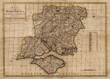
Map, hand coloured engraving, A Map of Hampshire, county map, scale about 6
miles to 1 inch, drawn by Haywood, engraved by Sudlow, published by John
Harrison, 115 Newgate Street, London, 16 December 1788.
|
|
map feature:-
|
hand coloured & title cartouche & scale line & lat and long grid
(oblique) & coast form lines & rivers & bridges & relief &
hillocks & beacons & woods & forests & county & hundreds
& table of hundreds & settlements & market days & roads |
|
scale line:-
|
12 miles = 64.9 mm |
|
inscription:- |
printed -on- map
A / MAP / OF / HAMPSHIRE / ENGRAVED FROM AN ACTUAL SURVEY / with
Improvements.
|
|
inscription:- |
printed -on- map, bottom left
Haywood Del
|
|
inscription:- |
printed -on- map, bottom centre
Engraved for J. Harrison, 115, Newgate Street, as the Act directs, Decr. 16,
1788.
|
|
inscription:- |
printed -on- map, bottom right
Sudlow Sculp.
|
|
dimension:- |
wxh, sheet = 51.5x38.5cm |
|
wxh, plate = 477x344mm |
|
wxh, map = 459x329mm |
|
scale = 1 to 300000 ? (1 to 297567 from scale line assuming statute mile) |
|
scale = 1 to 370000 ? (from town positions using DISTAB.exe) |
|
longitude, Winchester = 1d 14.3m W (approx) |
 |
|
|
reference:- |
Norgate, Martin; Norgate, Jean: 1997: Notes from Harrison's Map of Hampshire:
Hampshire CC Museums Service:: ISBN 1 85975 160 1 |

|
Map Group -- Harrison 1788 -- with Research Notes
|
 |
|
|
town names:-
|
|
Hampshire
|
Hampshire
|
|
map name
|
modern name
|
|
Alton
|
Alton
|
|
Andover
|
Andover
|
|
Basingstoke
|
Basingstoke
|
|
Bishops Waltham
|
Bishops Waltham
|
|
Christ Church
|
Christchurch
|
|
Fareham
|
Fareham
|
|
Fordingbridge
|
Fordingbridge
|
|
Gosport
|
Gosport
|
|
Havant
|
Havant
|
Clear
Kingsclere
|
Kingsclere
|
|
Lymington
|
Lymington
|
|
Alresford
|
Alresford
|
|
Odiham
|
Odiham
|
|
Petersfield
|
Petersfield
|
|
Portsmouth
|
Portsmouth
|
|
Ringwood
|
Ringwood
|
|
Rumsey
|
Romsey
|
|
Southampton
|
Southampton
|
|
Stockbridge
|
Stockbridge
|
|
Whitchurch
|
Whitchurch
|
|
Winchester
|
Winchester
|
|
 |
|

| top of page |
| MN: 4.10.2001 |


