|
B1990.1007.1:-
|
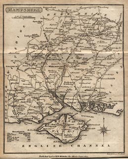
Map, uncoloured engraving, Hampshire, with the Isle of Wight, scale about 10
miles to 1 inch, engraved by Neele and Son, Strand, London, published by G and W
B Whittaker, Ave Maria Lane, London, 1821.
|
|
Frontispiece to The History and Topography of Hampshire, Pinnock's County
Histories series, published by Pinnock and Maunder, 267 Strand, London.
|
|
map feature:-
|
not coloured & title cartouche (shaded box) & compass rose (cardinal
half cardinal and false points, spear head for N) & scale line & table
of symbols & coast form lines & rivers (few, some labelled) & parks
& county & settlements & roads (graded by size) & roman roads
& antiquities (roman roads) & distances from London & canals |
|
inscription:- |
printed -on- title cartouche
HAMPSHIRE
|
|
inscription:- |
printed -on- bottom
Published by G. & W.B. Whittaker, Ave-Maria Lane, 1821. / Neele & Son, sc. [
] Strand
|
|
scale line:-
|
10 miles = 24.3 mm |
|
dimension:- |
wxh, image = 128x164mm |
|
scale = 1 to 660000 ? (1 to 662281 from scale line assuming modern mile) |
 |
|

|
Map Group -- Pinnock 1821 -- with Research Notes
|
 |
|
|
town names:-
|
|
Hampshire
|
Hampshire
|
|
map name
|
modern name
|
|
Alton
|
Alton
|
|
Andover
|
Andover
|
|
Basingstoke
|
Basingstoke
|
|
Bishops Waltham
|
Bishops Waltham
|
|
Christchurch
|
Christchurch
|
|
Fareham
|
Fareham
|
|
Fordingbridge
|
Fordingbridge
|
|
Gosport
|
Gosport
|
|
Havant
|
Havant
|
|
Kingsclere
|
Kingsclere
|
|
Lymington
|
Lymington
|
|
New Alresford
|
Alresford
|
|
Odiham
|
Odiham
|
|
Petersfield
|
Petersfield
|
|
Portsmouth
|
Portsmouth
|
|
Ringwood
|
Ringwood
|
|
Rumsey
|
Romsey
|
|
Southampton
|
Southampton
|
|
Stockbridge
|
Stockbridge
|
|
Whitchurch
|
Whitchurch
|
|
Winchester
|
Winchester
|
|
 |
|

| top of page |
| MN: 25.2.2002 |


