|
B1990.1148.1:-
|
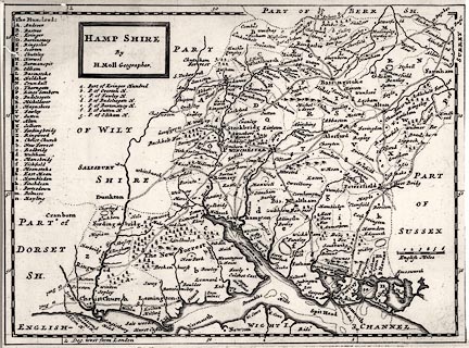
Map, uncoloured engraving, Hamp Shire ie Hampshire, scale about 6.5 miles to
1 inch, by Herman Moll, included in a New Description of England, published
1724.
|
|
map feature:-
|
not coloured & title cartouche ( plain box) & scale line & lat and
long scales & coast shaded & county & hundreds & table of
hundreds (keyed by letters A..Z, a..g, which is unusual) & rivers &
relief & woods & forests & parks & settlements & roads &
road distances |
|
scale line:-
|
6 miles = 26.1 mm |
|
inscription:- |
printed -on- title cartouche
HAMP SHIRE / By / H. Moll Geographer.
|
|
dimension:- |
wxh, map = 258x189mm |
|
scale = 1 to 370000 ? (1 to 369164 from scale line assuming statute mile) |
|
scale = 1 to 400000 ? (from town positions using DISTAB.exe) |
|
longitude, Winchester = 1d 17.4m W (approx) |
 |
|

|
Map Group -- Moll 1724 -- with Research Notes
|
 |
|
|
town names:-
|
|
Hamp Shire
|
Hampshire
|
|
map name
|
modern name
|
|
Alton
|
Alton
|
|
Andover
|
Andover
|
|
Basingstoke
|
Basingstoke
|
|
Bis. Waltham
|
Bishops Waltham
|
|
ChristChurch
|
Christchurch
|
|
Farham
|
Fareham
|
|
Fordingbridg
|
Fordingbridge
|
|
Gosport
|
Gosport
|
|
Havant
|
Havant
|
|
Kingscler
|
Kingsclere
|
|
Lemington
|
Lymington
|
|
Alesford
|
Alresford
|
|
Odiam
|
Odiham
|
|
Petersfield
|
Petersfield
|
|
Portsmouth
|
Portsmouth
|
|
Ringwood
|
Ringwood
|
|
Rumsey
|
Romsey
|
|
Southampton
|
Southampton
|
|
Stockbridg
|
Stockbridge
|
|
Whitchurch
|
Whitchurch
|
|
Winchester
|
Winchester
|
|
 |
|

| top of page |
| MN: 4.10.2001 |


