|
B1992.189.1:-
|
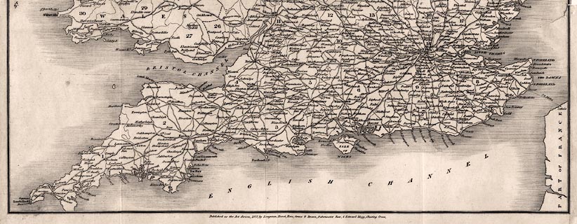
Road map, uncoloured engraving, General Map of the Roads of England and
Wales, scale about 24 miles to 1 inch, inserted in Paterson's Roads, by the late
LtCol Paterson, map by Edward Mogg, Charing Cross, London, 1822.
|
|
map feature:-
|
not coloured & mounted (silk?) & folded & table of symbols (road
types) & table of counties (keyed by number to map) & coast shaded &
country & county & settlements & roads & turnpike roads &
post roads |
|
inscription:- |
printed -on- map
A / GENERAL MAP / of the Roads / of / England and Wale; / Engraved for /
MOGG'S IMPROVED EDITION / OF / Paterson's Roads
-- title etc |
|
dimension:- |
scale = 1 to 1500000 ? (approx) |
 |
|

|
Map Group -- Mogg 1822
|
 |
|
|
town names:-
|
|
Alton
|
Hampshire
|
|
map name
|
modern name
|
|
Alton
|
Alton
|
|
Andover
|
Andover
|
|
Basingstoke
|
Basingstoke
|
|
Bishops Waltham
|
Bishops Waltham
|
|
Christchurch
|
Christchurch
|
|
Fareham
|
Fareham
|
|
Fordingbridge
|
Fordingbridge
|
|
Gosport
|
Gosport
|
|
Havant
|
Havant
|
|
Kingsclere
|
Kingsclere
|
|
Lymington
|
Lymington
|
|
Alresford
|
Alresford
|
|
Odiham
|
Odiham
|
|
Petersfield
|
Petersfield
|
|
Portsmouth
|
Portsmouth
|
|
Ringwood
|
Ringwood
|
|
Romsey
|
Romsey
|
|
Southampton
|
Southampton
|
|
Stockbri.
|
Stockbridge
|
|
Whitchurch
|
Whitchurch
|
|
Winchester
|
Winchester
|
|
 |
|

| top of page |
| MN: 4.10.2001 |


