|
FA1988.10:-
|
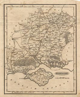
Map, uncoloured engraving, Hampshire, with the Isle of Wight, scale about 7
miles to 1 inch, by Benjamin Baker, Islington, London, 1792.
|
|
Published in a series in the Universal Magazine of Knowledge and Pleasure,
London.
|
|
map feature:-
|
not coloured & title cartouche (shaded oval) & scale line (chequered)
& lat and long scales & coast shaded & rivers & forests &
parks & settlements (graded by amount of buildings indicated) & roads
(graded by size) & electoral data (members of Parliament indicated?) |
|
inscription:- |
printed -on- title cartouche
HAMPSHIRE
|
|
inscription:- |
printed -on- below title
engrav'd by B. Baker Islington.
|
|
scale line:-
|
10 miles = 34.4 mm |
|
dimension:- |
wxh, sheet = 21.5x27cm |
|
wxh, plate = 194x244mm |
|
wxh, map = 183x229mm |
|
scale = 1 to 470000 ? (1 to 467824 from scale line assuming modern mile) |
|
longitude, Winchester = 1d 12.5m W (approx) |
 |
|

|
Map Group -- Baker 1792 -- with Research Notes
|
 |
|
|
town names:-
|
|
Hampshire
|
Hampshire
|
|
map name
|
modern name
|
|
Alton
|
Alton
|
|
Andover
|
Andover
|
|
Basingstoke
|
Basingstoke
|
|
Bishops Waltham
|
Bishops Waltham
|
|
Christchurch
|
Christchurch
|
|
Fareham
|
Fareham
|
|
Fordingbridge
|
Fordingbridge
|
|
Gosport
|
Gosport
|
|
Havant
|
Havant
|
|
Kingsclear
|
Kingsclere
|
|
Lymington
|
Lymington
|
|
Alresford
|
Alresford
|
|
Odiaham
|
Odiham
|
|
Petersfield
|
Petersfield
|
|
Portsmouth
|
Portsmouth
|
|
Ringwood
|
Ringwood
|
|
Rumsey
|
Romsey
|
|
Southampton
|
Southampton
|
|
Stockbridge
|
Stockbridge
|
|
Whitchurch
|
Whitchurch
|
|
Winchester
|
Winchester
|
|
 |
|

| top of page |
| MN: 1.8.2002 |


