|
FA1990.3.11:-
|
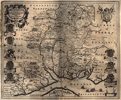
Map, uncoloured engraving, Hantonia, or Southantonensis, or Hantshire, ie
Hampshire and the Isle of Wight, scale about 3.5 miles to 1 inch, by Blaeu,
1645, published by John Blaeu, Amsterdam, Netherlands, 1662?
|
|
The reverse of the sheet, pages 123, 124 from its atlas, has the end of text
about Wiltshire which preceded this, and an incomplete entry for Hampshire; the
sheet probably comes from Theatrum Orbis Terrarum volume IV.
|
|
inscription:- |
printed -on- title cartouche
HANTONIA / SIVE / SOUTHANTONENSIS / COMITATUS / Vulgo / HANTSHIRE.
|
|
map feature:-
|
labelled borders (Septentrio, Oriens, Meridies, Occidens, at four edges of the
sheet) & scale line & coat of arms & coast shaded & county &
hundreds & relief & hillocks & forests & trees & beacons
& rivers & settlements & parks & swash lettering
(restrained) |
|
inscription:- |
printed -on- map by scale line
Mill. Angl. quoru~ 4 uni Germanica aequip.
-- 4 miles chequered in quarters, approx 37.1mm |
|
scale line:-
|
4 miles = 37.1 mm |
|
dimension:- |
wxh, plate = 50.5x42cm |
|
scale = 1 to 220000 ? (from town positions using DISTAB.exe) |
 |
|

|
Map Group -- Blaeu 1645 -- with Research Notes
|
 |
|

| top of page |
| MN: 4.10.2001 |


