|
FA1997.70:-
|
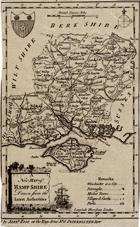
Map, uncoloured engraving, New Map of Hampshire, scale about 10.5 miles to 1
inch, Hampshire and the Isle of Wight, published by Alexander Hogg, at the Kings
Arms, 16 Paternoster Row, London, about 1784.
|
|
The map was published in Walpoole's New and Complete British Traveller.
|
|
map feature:-
|
not coloured & title cartouche & monumental cartouche & compass rose
& scale line & coat of arms (Southampton) & lat and long scales
(rectangular) & table of symbols & coast form lines & rivers &
relief & hillocks & forests & parks & settlements &
roads |
|
scale line:-
|
20 miles = 49.6 mm |
|
inscription:- |
printed -on- map
A / New MAP of / HAMPSHIRE / Drawn from the / Latest Authorities
-- stone plinth and a ship |
|
inscription:- |
printed -on- bottom
[Published] by ALEXR. HOGG at the Kings Arms No. 16 PATERNOSTER ROW
|
|
dimension:- |
wxh, map = 138x219mm |
|
scale = 1 to 650000 ? (1 to 648929 from scale line assuming statute mile) |
|
scale = 1 to 660000 ? (from town positions using DISTAB.exe) |
|
longitude, Winchester = 1d 13.6m W (approx) |
 |
|
|
reference:- |
Walpoole: 1784: New and Complete British Traveller: Hogg, Alexander
(London) |

|
Map Group -- Hogg 1784 -- with Research Notes
|
 |
|
|
town names:-
|
|
Hamp Shire
|
Hampshire
|
|
map name
|
modern name
|
|
Alton
|
Alton
|
|
Andover
|
Andover
|
|
Basingstoke
|
Basingstoke
|
|
Bps. Waltham
|
Bishops Waltham
|
|
Christ Church
|
Christchurch
|
|
Fareham
|
Fareham
|
|
Fordingbridge
|
Fordingbridge
|
|
Gosport
|
Gosport
|
|
Havant
|
Havant
|
|
Kingsclere
|
Kingsclere
|
|
Lymington
|
Lymington
|
|
Alresford
|
Alresford
|
|
Odiam
|
Odiham
|
|
Petersfield
|
Petersfield
|
|
Portsmouth
|
Portsmouth
|
|
Ringwood
|
Ringwood
|
|
Rumsey
|
Romsey
|
|
Southampton
|
Southampton
|
|
Stockbridge
|
Stockbridge
|
|
Whitchurch
|
Whitchurch
|
|
Winchester
|
Winchester
|
|
 |
|

| top of page |
| MN: 4.10.2001 |


