|
FA1997.97:-
|
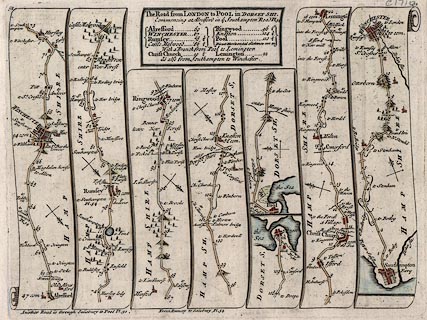
Strip map, road map, hand coloured engraving, scale about 2-2.5 miles to 1
inch, The Road from London to Pool in Dorsetshire, segment from Alresford,
Hampshire to Poole, Dorset and from there to Lymington, Lymington, and from
Southampton to Winchester, Hampshire, and on the other side The Road from London
to Shrewsbury, Meriden, Warwickshire to Shrewsbury, Shropshire and from there to
Welshpool, Montgomeryshire, from a road book by John Senex, 1719, edition
printed for John Bowles and Son, The Black Horse, Cornhill, London, after
1757.
|
|
From Roads through England Delineated; ... Ogilby's survey revised, improved and
reduced to a size portable for the pocket.
|
|
Pl.52 New Alresford, Winchester, Romsey, and Ringwood, Hampshire; Christchurch,
and Poole, Dorset; there to Lymington, Lymington and Pennington, Hampshire;
Southampton, and Winchester, Hampshire.
|
|
Pl.53 Meriden, and Birmingham, Warwickshire; Dudley, Staffordshire; Bridgnorth,
Great Wenlock, and Shrewsbury, Shropshire; then to Welshpool, Montgomeryshire.
|
|
Note - the plate number is at top left and right, the map is double sided.
|
|
inscription:- |
printed -on- title cartouche
The Road from LONDON to POOL in DORSETSHI. / Commencing at Alresford in ye
Southampton Road Pl54 ... As also from Southampton to Winchester.
-- title and table of distances |
|
inscription:- |
printed -on- title cartouche
The Road from LONDON to SHREWSBURY / Continued to Welshpool in North Wales /
Commencing at Meriden in the Road to Holy Head / Plate 22
-- title and table of distances |
|
map feature:-
|
title cartouche (plain box, sides curved to fit by scrolls of map) & north
point (simple cross marked with fleur de lys for N and cross for E) & road
distances (miles from Cornhill, London, dot in road, figure beside) & table
of distances & roads (continuous or dotted lines probably indicate fenced or
unfenced?) & settlements (differences in size and typeface of name are
indications of size) & streets (layout in some towns) & rivers &
ferries & windmills & parks & woods & forests & relief &
hillocks (all one way up, ie not using a convention for up and down) &
county (dotted line boundary and comment as 'enter Hamsphire') |
|
dimension:- |
wxh, plate = 212x156mm |
|
scale = 1 to 150000 ? (approx) |
 |
|

|
Map Group -- Senex 1757 -- with Research Notes
|
 |
|
|
town names:-
|
|
Hampshire
|
Hampshire
|
|
map name
|
modern name
|
|
Christ Church
|
Christchurch
|
|
Lemingto~
|
Lymington
|
|
Alresford
|
Alresford
|
|
Ringwood
|
Ringwood
|
|
Rumsey
|
Romsey
|
|
Southampton
|
Southampton
|
|
Winchester
|
Winchester
|
|
 |
|

| top of page |
| MN: 4.10.2001 |


