|
FA1997.101:-
|
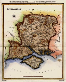
Map, Southampton, ie Hampshire, scale about 7 miles to 1 inch, drawn by R
Creighton, engraved by J and C Walker, for the Topographical Dictionary
published by Lewis, London? about 1830s-40s?
|
|
The electoral information is that after the Reform Act 1834.
|
|
scale line:-
|
20 miles = 75.4 mm |
|
inscription:- |
printed -on- PLACE of ELECTION for the NORTHERN DIVISION._ Winchester. / POLLING
PLACES _ Alton. Andover. Basingstoke. Bishop's Waltham. Kingsclere. Odiham.
Petersfield. / PLACE of ELECTION for the SOUTHERN DIVISION._ Southampton. /
POLLING PLACES _ Fareham. Lymington. Portsmouth. Ringwood. Romsey.
|
|
inscription:- |
printed -on- upper left
SOUTHAMPTON
|
|
inscription:- |
printed -on- bottom
Drawn by R. Creighton DRAWN AND ENGRAVED FOR LEWIS' TOPOGRAPHICAL
DICTIONARY. Engraved by J&C Walker.
|
|
map feature:-
|
compass rose & scale line & lat and long scales & county & roads
& settlements & relief & hill hachuring (and coloured) & rivers
& electoral data & harbours |
|
dimension:- |
wxh, sheet = 27x33cm |
|
wxh, map = 234x288mm |
|
scale = 1 to 430000 ? (1 to 426882 from scale line assuming statute mile) |
|
scale = 1 to 440000 ? (1 deg lat = 254.8mm is 1 to 436885) |
 |
|

|
Map Group -- Lewis 1831 -- with Research Notes
|
 |
|
|
town names:-
|
|
Southampton
|
Hampshire
|
|
map name
|
modern name
|
|
Alton
|
Alton
|
|
Andover
|
Andover
|
|
Basingstoke
|
Basingstoke
|
|
Bishops Waltham
|
Bishops Waltham
|
|
Christchurch
|
Christchurch
|
|
Fareham
|
Fareham
|
|
Fordingbridge
|
Fordingbridge
|
|
Gosport
|
Gosport
|
|
Havant
|
Havant
|
|
Kingsclere
|
Kingsclere
|
|
Lymington
|
Lymington
|
|
New Alresford
|
Alresford
|
|
Odiham
|
Odiham
|
|
Petersfield
|
Petersfield
|
|
Portsmouth
|
Portsmouth
|
|
Ringwood
|
Ringwood
|
|
Romsey
|
Romsey
|
|
Southampton
|
Southampton
|
|
Stockbridge
|
Stockbridge
|
|
Whitchurch
|
Whitchurch
|
|
Winchester
|
Winchester
|
|
 |
|

| top of page |
| MN: 4.10.2001 |


